File:Mount Adams summit area.jpg

Size of this preview: 800 × 573 pixels. Other resolutions: 320 × 229 pixels | 640 × 458 pixels | 1,024 × 733 pixels | 1,280 × 916 pixels | 3,075 × 2,201 pixels.
Original file (3,075 × 2,201 pixels, file size: 3.12 MB, MIME type: image/jpeg)
| This is a file from the Wikimedia Commons. The description on its description page there is shown below.
|
Summary
| Camera location | | View this and other nearby images on: OpenStreetMap |
|---|
| Description |
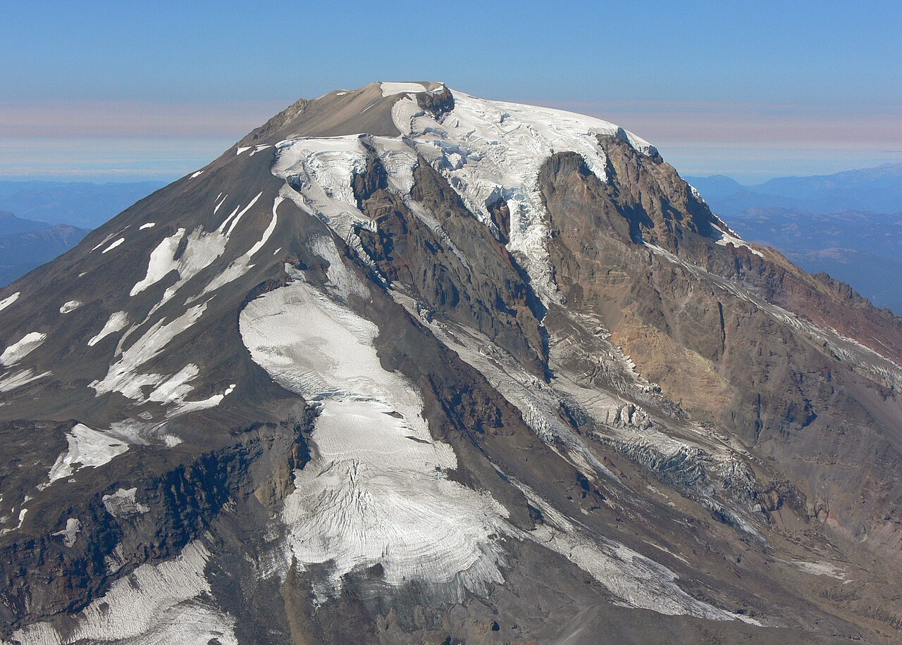
English: Mount Adams (Washington) from the southeast; summit, left center skyline; Pikers Peak, below left; two branches of Klickitat Glacier separated by the east face of Pikers Peak, one branch descends from summit ice cap, the other from the Pikers Peak ice cap; Battlement Ridge is beyond Klickitat Glacier and descends eastward (right) from summit ice cap; Rusk Glacier is just visible above Battlement Ridge descending from Roosevelt Cliff; Sunrise Camp (not visible) is near the high point of the moraine in the lower right. |
| Date | |
| Source | Own work |
| Author | Xpda |
Licensing
Xpda, the copyright holder of this work, hereby publishes it under the following licenses:
This file is licensed under the Creative Commons Attribution 3.0 Unported license.
Attribution:
Xpda
- You are free:
- to share – to copy, distribute and transmit the work
- to remix – to adapt the work
- Under the following conditions:
- attribution – You must give appropriate credit, provide a link to the license, and indicate if changes were made. You may do so in any reasonable manner, but not in any way that suggests the licensor endorses you or your use.

|
Permission is granted to copy, distribute and/or modify this document under the terms of the GNU Free Documentation License, Version 1.2 or any later version published by the Free Software Foundation; with no Invariant Sections, no Front-Cover Texts, and no Back-Cover Texts. A copy of the license is included in the section entitled GNU Free Documentation License. |
You may select the license of your choice.
Original upload log
| date/time | username | resolution | size | edit summary | |
|---|---|---|---|---|---|
| 15:58, 11 February 2008 | User:Xpda | <a href="http://upload.wikimedia.org/wikipedia/commons/d/df/P1180215.JPG"><img alt="Thumbnail for version as of 15:58, 11 February 2008" src="http://upload.wikimedia.org/wikipedia/commons/thumb/d/df/P1180215.JPG/120px-P1180215.JPG" width="120" height="90" border="0" /></a> | 3,264×2,448 | 2.45 MB | {{Information |Description=Mount Adams, Washington |Source=self-made |Date=09/21/2007 |Author= <a href="/wiki/User:Xpda" title="User:Xpda">Xpda</a> |Permission= |other_versions= }} |
File history
Click on a date/time to view the file as it appeared at that time.
| Date/Time | Dimensions | User | Comment | |
|---|---|---|---|---|
| current | 21:12, 29 November 2014 | 3,075 × 2,201 (3.12 MB) | Wsiegmund | Adobe Photoshop Elements 11.0; Straighten, 20% Auto Smart Fix, Adjust Lighting/Shadows/Highlights, Levels tools |
File usage
The following page uses this file: