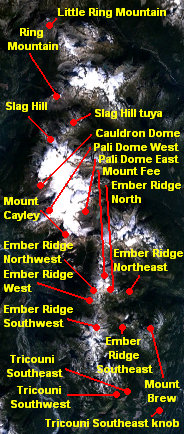
File:Mount Cayley volcanic field NASA.png

Mount_Cayley_volcanic_field_NASA.png(184 × 434 pixels, file size: 176 KB, MIME type: image/png)

Commons-logo.svg This is a file from the Wikimedia Commons. The description on its description page there is shown below.
Commons is a freely licensed media file repository. You can help.

Summary

Description
English: Map of the Mount Cayley volcanic field in southwestern British Columbia, Canada.
Date
Source Own work using NASA World Wind. The volcano locations are based on the use of volcano coordinates on the National Resources Canada website: Little Ring Mountain, Ring Mountain, Slag Hill, Slag Hill tuya, Cauldron Dome, Mount Cayley, Pali Dome East, Pali Dome West, Mount Fee, Ember Ridge Northeast, Ember Ridge North, Ember Ridge Northwest, Ember Ridge West, Ember Ridge Southwest, Ember Ridge Southeast, Mount Brew, Tricouni Southwest, Tricouni Southeast flows, Tricouni Southeast knob.
Author Black Tusk

Licensing

Public domain I, the copyright holder of this work, release this work into the public domain. This applies worldwide.
In some countries this may not be legally possible; if so:
I grant anyone the right to use this work for any purpose, without any conditions, unless such conditions are required by law.

Captions

Add a one-line explanation of what this file represents

Items portrayed in this file

depicts

2 April 2010

File history

Click on a date/time to view the file as it appeared at that time.

Date/TimeDimensionsUserComment
current17:42, 2 April 2010184 × 434 (176 KB)Black Tusk Correcting spelling error; Ember Ridge Northeast --> Ember Ridge Northwest

The following page uses this file: