File:Nail cleaner (FindID 792020).jpg

Size of this preview: 450 × 600 pixels. Other resolutions: 180 × 240 pixels | 360 × 480 pixels | 576 × 768 pixels | 1,200 × 1,600 pixels.
Original file (1,200 × 1,600 pixels, file size: 727 KB, MIME type: image/jpeg)
| This is a file from the Wikimedia Commons. The description on its description page there is shown below.
|
.jpg)
Summary
| nail cleaner | |||
|---|---|---|---|
| Photographer |
Royal Institution of Cornwall, Anna Tyacke, 2016-06-25 16:19:52 |
||
| Title |
nail cleaner |
||
| Description |
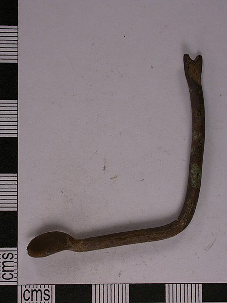
English: Cast copper alloy Roman toiletry implement, with an oval spoon bowl at one end, probably an ear scoop or ligula, and a pointed bifid terminal at the other end, which might have been used as a nail cleaner . The toiletry implement is now bent into a V-shape but would have originally been straight. Roman toiletry implements often have multiple functions, with a tool at each end of the copper alloy rod.
Bailey (2008) illustrates a similar bronze probe with a bowl terminal on page 25, fig.C7.14, which is dated from the Roman period. Crummy (1983) illustrates a similar nail cleaner on page 58, fig.62, no.1869, which is dated from the 1st to the 2nd century AD, and a toilet spoon on page 60, fig.64, no.1900. See <a href="https://finds.org.uk/database/artefacts/record/id/507639" title="View details for CORN-9C88B2">CORN-9C88B2</a> for a similar example that is dated from the Roman period. |
||
| Depicted place | (County of findspot) Dorset | ||
| Date | between 43 and 410 | ||
| Accession number |
FindID: 792020 Old ref: CORN-D183AE Filename: June16finds154.JPG |
||
| Credit line |
|
||
| Source |
https://finds.org.uk/database/ajax/download/id/572249 Catalog: https://finds.org.uk/database/images/image/id/572249/recordtype/artefacts archive copy at the Wayback Machine Artefact: https://finds.org.uk/database/artefacts/record/id/792020 |
||
| Permission (Reusing this file) |
Attribution License version 2.0 (verified 14 November 2020) | ||
| Object location | | View this and other nearby images on: OpenStreetMap |
|---|
.jpg¶ms=050.848400_N_-002.439450_E_globe:Earth_class:object_type:object__&language=en)
Licensing
This file is licensed under the Creative Commons Attribution 2.0 Generic license.
Attribution: Royal Institution of Cornwall
- You are free:
- to share – to copy, distribute and transmit the work
- to remix – to adapt the work
- Under the following conditions:
- attribution – You must give appropriate credit, provide a link to the license, and indicate if changes were made. You may do so in any reasonable manner, but not in any way that suggests the licensor endorses you or your use.
File history
Click on a date/time to view the file as it appeared at that time.
| Date/Time | Dimensions | User | Comment | |
|---|---|---|---|---|
| current | 07:57, 2 February 2019 | 1,200 × 1,600 (727 KB) | Fæ | Portable Antiquities Scheme, CORN, FindID: 792020, roman, page 3764, batch count 7313 |
File usage
The following page uses this file:
.jpg)