File:Netherlands with provinces.png
No higher resolution available.
Netherlands_with_provinces.png (200 × 235 pixels, file size: 23 KB, MIME type: image/png)
| This is a file from the Wikimedia Commons. The description on its description page there is shown below.
|
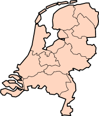
Description: Map of the Netherlands, with provinces. Description: Map for localisazion of the province of Friesland in the Netherlands.
Clickable version


|
Permission is granted to copy, distribute and/or modify this document under the terms of the GNU Free Documentation License, Version 1.2 or any later version published by the Free Software Foundation; with no Invariant Sections, no Front-Cover Texts, and no Back-Cover Texts. A copy of the license is included in the section entitled GNU Free Documentation License. |
| This file is licensed under the Creative Commons Attribution-Share Alike 3.0 Unported license. | ||
| ||
| This licensing tag was added to this file as part of the GFDL licensing update. |
| Annotations | This image is annotated: View the annotations at Commons |


File history
Click on a date/time to view the file as it appeared at that time.
| Date/Time | Dimensions | User | Comment | |
|---|---|---|---|---|
| current | 06:59, 30 July 2005 | 200 × 235 (23 KB) | J.Hollemans~commonswiki | '''Description:''' Map of the Netherlands, with provinces. {{GFDL}} Category:Maps of Netherlands |
File usage
The following 15 pages use this file:
- Drenthe
- Flevoland
- Friesland
- Gelderland
- Groningen (province)
- Limburg (Netherlands)
- North Brabant
- North Holland
- Overijssel
- South Holland
- Utrecht (province)
- Zeeland
- Template:ProvincesOfTheNetherlands
- Template:Provinces of the Netherlands
- Template:Small clicksensitive map of provinces of the Netherlands