File:Nevado del Ruiz hazard map, from Wright and Pierson.png
No higher resolution available.
Nevado_del_Ruiz_hazard_map,_from_Wright_and_Pierson.png (675 × 450 pixels, file size: 324 KB, MIME type: image/png)
| This is a file from the Wikimedia Commons. The description on its description page there is shown below.
|

|
This image (or all images in this category) uses inside labels or attached captions in a specific script or language and should be converted to a language neutral form. This would allow its use in all Wikimedia projects and, more importantly, all Wikimedia languages.
|

|
This map image could be re-created using vector graphics as an SVG file. This has several advantages; see Commons:Media for cleanup for more information. If an SVG form of this image is available, please upload it and afterwards replace this template with
{{vector version available|new image name}}.
It is recommended to name the SVG file “Nevado del Ruiz hazard map, from Wright and Pierson.svg”—then the template Vector version available (or Vva) does not need the new image name parameter. |
Summary
| Description |
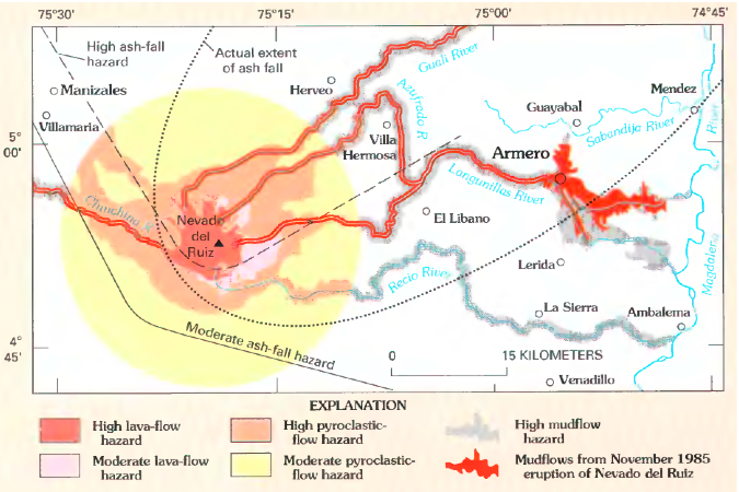
English: Volcanic hazard map for Nevado del Ruiz. Lahars from 1985 eruption (which killed around 23,000 people) shown in red.
Original caption: "Map showing hazards expected from an eruption of Nevado del Ruiz, Colombia. Such a map was prepared by INGEOMINAS (Colombian Institute of Geology and Mines) and circulated 1 month prior to the November 13, 1985, eruption of Nevado del Ruiz. Map shows danger from mudflows in the valley occupied by the town of Armero, Colombia, as well as areas affected by the hazards that resulted from this eruption. Circle denotes 20-kilometer limit." |
| Date | |
| Source | Page 21 in Wright, Thomas L. and Pierson, Thomas C. (1992). Living with volcanoes (DJVU format), USGS Circular 1073. Bibliographic information and link to DJVU reader are online here. |
| Author | Wright, Thomas L. and Pierson, Thomas C. |
| Other versions |
|

Licensing
This image is in the public domain in the United States because it only contains materials that originally came from the United States Geological Survey, an agency of the United States Department of the Interior. For more information, see the official USGS copyright policy.
|
File history
Click on a date/time to view the file as it appeared at that time.
| Date/Time | Dimensions | User | Comment | |
|---|---|---|---|---|
| current | 08:38, 19 February 2011 | 675 × 450 (324 KB) | Lluis tgn | Reverted to version as of 23:46, 31 March 2009. It was in catalan |
File usage
The following page uses this file: