File:North yorkshire moors railway map.gif
Size of this preview: 800 × 593 pixels. Other resolutions: 320 × 237 pixels | 640 × 474 pixels | 1,024 × 759 pixels | 1,198 × 888 pixels.
Original file (1,198 × 888 pixels, file size: 73 KB, MIME type: image/gif)
| This is a file from the Wikimedia Commons. The description on its description page there is shown below.
|
| Description |
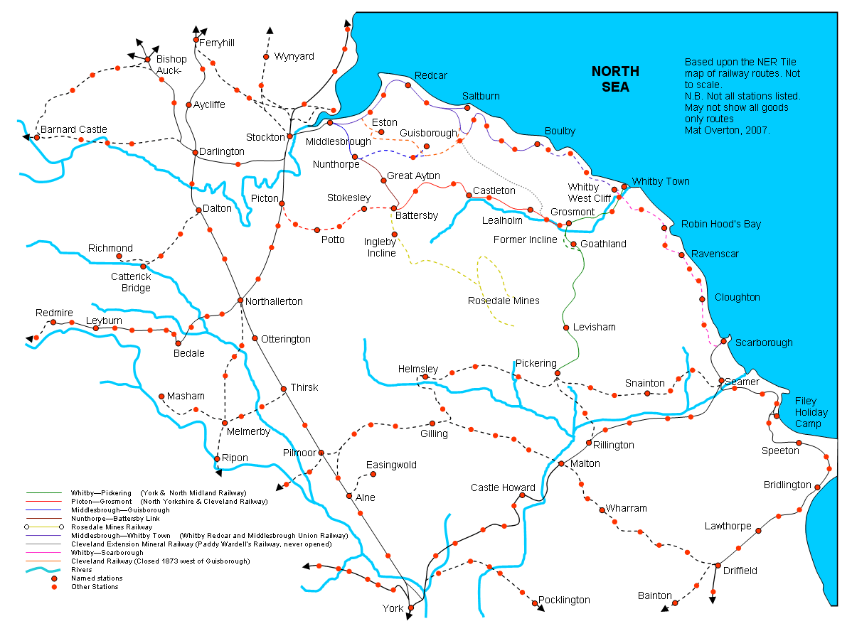
English: Map of former and existing railway lines across the North Yorkshire Moors, Mat Overton, 2006 |
| Date | 30 March 2007 (original upload date) |
| Source | Transferred from en.wikipedia to Commons by Oxyman using CommonsHelper. |
| Author | Original uploader was Maniac Pony (talk) at en.wikipedia |
Licensing
Maniac Pony, the copyright holder of this work, hereby publishes it under the following licenses:
| This file is licensed under the Creative Commons Attribution-Share Alike 3.0 Unported license. Subject to disclaimers. | ||
| Attribution: Maniac Pony | ||
| ||
| This licensing tag was added to this file as part of the GFDL licensing update. |

|
Permission is granted to copy, distribute and/or modify this document under the terms of the GNU Free Documentation License, Version 1.2 or any later version published by the Free Software Foundation; with no Invariant Sections, no Front-Cover Texts, and no Back-Cover Texts. A copy of the license is included in the section entitled GNU Free Documentation License. Subject to disclaimers. |
This file is licensed under the Creative Commons Attribution 2.5 Generic license.
Attribution:
- You are free:
- to share – to copy, distribute and transmit the work
- to remix – to adapt the work
- Under the following conditions:
- attribution – You must give appropriate credit, provide a link to the license, and indicate if changes were made. You may do so in any reasonable manner, but not in any way that suggests the licensor endorses you or your use.
You may select the license of your choice.
Original upload log
The original description page was here. All following user names refer to en.wikipedia.
- 2007-03-30 08:19 Achmelvic 1198×888× (74418 bytes) Moved Northallerton name to correct position
- 2007-03-17 11:14 Maniac Pony 1198×888× (75557 bytes) Map of former and existing railway lines across the North Yorkshire Moors and surrounding area, Mat Overton, 2007
- 2007-03-12 19:43 Maniac Pony 1133×838× (71220 bytes) Map of former and existing railway lines across the North Yorkshire Moors, Mat Overton, 2006 - 2007
- 2006-12-30 19:43 Maniac Pony 921×590× (25882 bytes) Map of former and existing railway lines across the North Yorkshire Moors, Mat Overton, 2006
- 2006-12-30 19:41 Maniac Pony 921×590× (25882 bytes) Map of former and existing railway lines across the North Yorkshire Moors, Mat Overton, 2006
- 2006-12-30 19:40 Maniac Pony 921×590× (25882 bytes) Map of former and existing railway lines across the North Yorkshire Moors, Mat Overton, 2006
- 2006-12-30 19:39 Maniac Pony 921×590× (25882 bytes) Map of former and existing railway lines across the North Yorkshire Moors, Mat Overton, 2006
- 2006-12-10 13:57 Maniac Pony 938×573× (25565 bytes) Map of former and existing railway lines across the North Yorkshire Moors, Mat Overton, 2006
File history
Click on a date/time to view the file as it appeared at that time.
| Date/Time | Dimensions | User | Comment | |
|---|---|---|---|---|
| current | 06:04, 19 November 2010 | 1,198 × 888 (73 KB) | Prioryman | Corrected date of closure of Cleveland Railway line west of Guisborough (1873 not 1866) |
File usage
The following page uses this file: