File:Oregoncountry2.png

Size of this preview: 588 × 599 pixels. Other resolutions: 235 × 240 pixels | 471 × 480 pixels | 589 × 600 pixels | 992 × 1,011 pixels.
Original file (992 × 1,011 pixels, file size: 1.04 MB, MIME type: image/png)
| This is a file from the Wikimedia Commons. The description on its description page there is shown below.
|
Summary
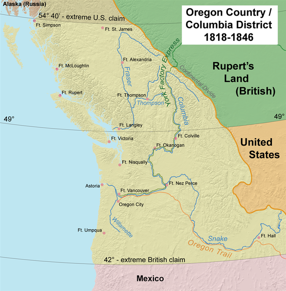
| Description | This map shows Oregon Country, 1818–1846 |
| Date | 6 April 2006 (original upload date) |
| Source | Own work by the original uploader. See Charles O. Paullin and John K. Wright's Atlas of the Historical Geography of the United States (1932) for PD maps which support these. |
| Author | Kmusser |
| Other versions | Esperanto |
Licensing
I, the copyright holder of this work, hereby publish it under the following license:
This file is licensed under the Creative Commons Attribution-Share Alike 2.5 Generic license.
- You are free:
- to share – to copy, distribute and transmit the work
- to remix – to adapt the work
- Under the following conditions:
- attribution – You must give appropriate credit, provide a link to the license, and indicate if changes were made. You may do so in any reasonable manner, but not in any way that suggests the licensor endorses you or your use.
- share alike – If you remix, transform, or build upon the material, you must distribute your contributions under the same or compatible license as the original.
File history
Click on a date/time to view the file as it appeared at that time.
| Date/Time | Dimensions | User | Comment | |
|---|---|---|---|---|
| current | 09:03, 20 May 2017 | 992 × 1,011 (1.04 MB) | Ras67 | cropped |
File usage
The following page uses this file: