File:Ottawa-shootings-map.png

Size of this preview: 800 × 428 pixels. Other resolutions: 320 × 171 pixels | 640 × 342 pixels | 1,024 × 548 pixels | 1,896 × 1,014 pixels.
Original file (1,896 × 1,014 pixels, file size: 730 KB, MIME type: image/png)
| This is a file from the Wikimedia Commons. The description on its description page there is shown below.
|
Summary
| Description |
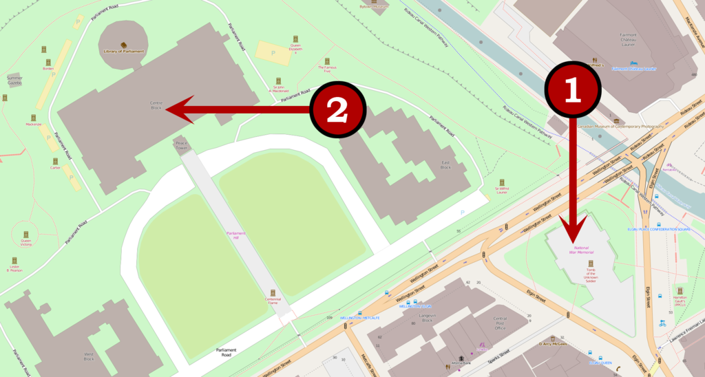
English: A map of the locations of the 2014 shootings at Parliament Hill, Ottawa. Français : Carte des endroits touchés par la fusillade du 22 octobre 2014 à Ottawa. |
|||
| Date | ||||
| Source | Originally a map on OpenStreetMap | |||
| Author | User:Veggies | |||
| Permission (Reusing this file) |
This file is licensed under the Creative Commons Attribution-Share Alike 2.0 Generic license.
|
| Camera location | | View this and other nearby images on: OpenStreetMap |
|---|
Licensing
| This work contains information from OpenStreetMap, which is made available under the Open Database License (ODbL).
The ODbL does not require any particular license for maps produced from ODbL data. Prior to 1 August 2020, map tiles produced by the OpenStreetMap Foundation were licensed under the CC-BY-SA-2.0 license. Maps produced by other people may be subject to other licences. |
This file is licensed under the Creative Commons Attribution-Share Alike 2.0 Generic license.
- You are free:
- to share – to copy, distribute and transmit the work
- to remix – to adapt the work
- Under the following conditions:
- attribution – You must give appropriate credit, provide a link to the license, and indicate if changes were made. You may do so in any reasonable manner, but not in any way that suggests the licensor endorses you or your use.
- share alike – If you remix, transform, or build upon the material, you must distribute your contributions under the same or compatible license as the original.
File history
Click on a date/time to view the file as it appeared at that time.
| Date/Time | Dimensions | User | Comment | |
|---|---|---|---|---|
| current | 11:19, 23 October 2014 | 1,896 × 1,014 (730 KB) | Veggies | Updated second shooting location now that more up-to-date info given. |
File usage
The following page uses this file: