File:Parinacota Volcano, South America.JPG

Size of this preview: 800 × 531 pixels. Other resolutions: 320 × 213 pixels | 640 × 425 pixels | 1,024 × 680 pixels | 1,280 × 850 pixels | 4,288 × 2,848 pixels.
Original file (4,288 × 2,848 pixels, file size: 10.67 MB, MIME type: image/jpeg)
| This is a file from the Wikimedia Commons. The description on its description page there is shown below.
|
Summary
| Description |
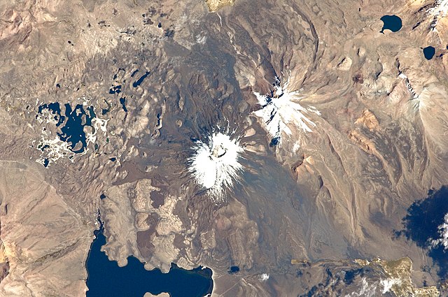
English: This astronaut photograph from the International Space Station highlights the symmetrical cone of Parinacota, with its well-developed summit crater (elevation 6,348 meters above sea level). Dark brown to dark gray surfaces to the east and west of the summit include lava flows, pyroclastic deposits, and ash.
A companion volcano, Pomerape, is located across a low saddle to the north. This volcano last erupted during the Pleistocene Epoch (approximately 3 million to 12,000 years ago). Together, Parinacota and Pomerape form the Nevados de Payachata volcanic area. The summits of both volcanoes are covered by white snowpack and small glaciers. Eruptive activity at Parinacota has directly influenced development of the local landscape, beyond the placement of volcanic deposits. Approximately 8,000 years ago, the western flank of the volcano collapsed, creating a debris avalanche that travelled 22 kilometres to the west. The debris blocked rivers and streams, leading to the formation of Chungará Lake to the south (lower left). The uneven, hummocky surface of the avalanche debris provides ample catchments for water, as evidenced by the numerous small ponds and Cotacotani Lake to the west. |
| Date | |
| Source | NASA Earth Observatory |
| Author | ISS Expedition 29 crew |
| Camera location | | View this and other nearby images on: OpenStreetMap |
|---|
This image or video was catalogued by Johnson Space Center of the United States National Aeronautics and Space Administration (NASA) under Photo ID: ISS029-E-20003. This tag does not indicate the copyright status of the attached work. A normal copyright tag is still required. See Commons:Licensing. Other languages:
|
Image acquired with a Nikon D2Xs digital camera using a 400 mm lens, and is provided by the ISS Crew Earth Observations experiment and Image Science & Analysis Laboratory, Johnson Space Center.
Licensing
| This file is in the public domain in the United States because it was solely created by NASA. NASA copyright policy states that "NASA material is not protected by copyright unless noted". (See Template:PD-USGov, NASA copyright policy page or JPL Image Use Policy.) | ||
 |
Warnings:
|
| Annotations | This image is annotated: View the annotations at Commons |
File history
Click on a date/time to view the file as it appeared at that time.
| Date/Time | Dimensions | User | Comment | |
|---|---|---|---|---|
| current | 06:26, 17 October 2011 | 4,288 × 2,848 (10.67 MB) | Originalwana | {{Information |Description ={{en|1=This astronaut photograph from the International Space Station highlights the symmetrical cone of Parinacota, with its well-developed summit crater (elevation 6,348 meters above sea level). Dark brown to dark |
File usage
The following page uses this file: