File:Penzing (Wien) - Otto-Wagner-Villa, Hüttelbergstraße 26 (2).JPG

Size of this preview: 800 × 551 pixels. Other resolutions: 320 × 220 pixels | 640 × 440 pixels | 1,024 × 705 pixels | 1,280 × 881 pixels | 3,771 × 2,595 pixels.
Original file (3,771 × 2,595 pixels, file size: 8.14 MB, MIME type: image/jpeg)
| This is a file from the Wikimedia Commons. The description on its description page there is shown below.
|
Summary
| Description |
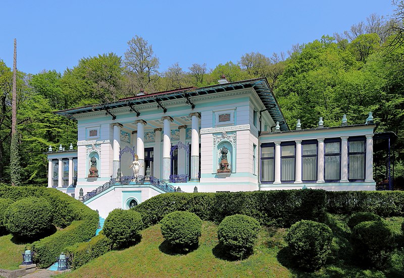
Deutsch: Die Otto-Wagner-Villa an der Adresse Hüttelbergstraße 26 im 14. Wiener Gemeindebezirk Penzing.
Die Villa hat der Architekt Otto Wagner von 1886 bis 1888 zum eigenen Gebrauch errichtet. Die linke Pergola wurde 1900 zum Atelier umgebaut. 1911 verkaufte er die Villa und errichtete sich eine neue an der Adresse Hüttelbergstraße 28. Im Jahr 1972 erwarb der Maler Ernst Fuchs das Gebäude und wird (Stand 2018) als Ernst-Fuchs-Museum genutzt. |
| Date | |
| Source | Own work |
| Author | C.Stadler/Bwag |
| Permission (Reusing this file) |
Deutsch: Hallo, du darfst mein Foto kostenlos nutzen, aber nenne mich bitte als Fotograf, beispielsweise „Foto: C.Stadler/Bwag“ oder © C.Stadler/Bwag; CC-BY-SA-4.0. Auf mehr Angaben bestehe ich nicht - im Gegensatz zu manch anderen, die die Vorgaben der unten angeführten Lizenzierung auf Punkt und Beistrich einfordern. English: Feel free to use my photos, but please mention me as the author like © C.Stadler/Bwag or © C.Stadler/Bwag; CC-BY-SA-4.0 (that's good enough) and if you want send me a message: bwag@gmx.net. |
| Other versions |
|
_-_Otto-Wagner-Villa,_H%C3%BCttelbergstra%C3%9Fe_26_(1).JPG)
_-_Otto-Wagner-Villa,_H%C3%BCttelbergstra%C3%9Fe_26_(2).JPG)
| Camera location | | View this and other nearby images on: OpenStreetMap |
|---|
_-_Otto-Wagner-Villa,_H%C3%BCttelbergstra%C3%9Fe_26_(2).JPG¶ms=048.209631_N_0016.255682_E_globe:Earth_type:camera_heading:40.00&language=en)
| Object location | | View this and other nearby images on: OpenStreetMap |
|---|
_-_Otto-Wagner-Villa,_H%C3%BCttelbergstra%C3%9Fe_26_(2).JPG¶ms=048.209907_N_0016.255902_E_globe:Earth_class:object_type:object_region:AT-9_&language=en)
Licensing
I, the copyright holder of this work, hereby publish it under the following license:
This file is licensed under the Creative Commons Attribution-Share Alike 4.0 International license.
- You are free:
- to share – to copy, distribute and transmit the work
- to remix – to adapt the work
- Under the following conditions:
- attribution – You must give appropriate credit, provide a link to the license, and indicate if changes were made. You may do so in any reasonable manner, but not in any way that suggests the licensor endorses you or your use.
- share alike – If you remix, transform, or build upon the material, you must distribute your contributions under the same or compatible license as the original.
File history
Click on a date/time to view the file as it appeared at that time.
| Date/Time | Dimensions | User | Comment | |
|---|---|---|---|---|
| current | 04:18, 24 April 2018 | 3,771 × 2,595 (8.14 MB) | Bwag | b |
File usage
The following page uses this file:
_-_Otto-Wagner-Villa,_Hüttelbergstraße_26_(2).JPG)