File:Ph Territorial Map.png

Size of this preview: 584 × 600 pixels. Other resolutions: 234 × 240 pixels | 467 × 480 pixels | 748 × 768 pixels | 997 × 1,024 pixels | 1,827 × 1,877 pixels.
Original file (1,827 × 1,877 pixels, file size: 612 KB, MIME type: image/png)
| This is a file from the Wikimedia Commons. The description on its description page there is shown below.
|

|
This map image could be re-created using vector graphics as an SVG file. This has several advantages; see Commons:Media for cleanup for more information. If an SVG form of this image is available, please upload it and afterwards replace this template with
{{vector version available|new image name}}.
It is recommended to name the SVG file “Ph Territorial Map.svg”—then the template Vector version available (or Vva) does not need the new image name parameter. |
Summary
| Description |
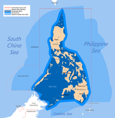
English: Territorial map claimed by the Philippines, showing internal waters, territorial sea, international treaty limits and exclusive economic zone. |
| Date | 25 June 2007 (original upload) |
| Source | English Wikipedia (log) |
| Author | Roel Balingit (username: Namayan); addition of Benham Rise and Indo-PH EEZs: Ervin Malicdem (schadow1) |
Licensing
Roel Balingit (username: Namayan), the copyright holder of this work, hereby publishes it under the following licenses:

|
Permission is granted to copy, distribute and/or modify this document under the terms of the GNU Free Documentation License, Version 1.2 or any later version published by the Free Software Foundation; with no Invariant Sections, no Front-Cover Texts, and no Back-Cover Texts. A copy of the license is included in the section entitled GNU Free Documentation License. |
This file is licensed under the Creative Commons Attribution 2.5 Generic license.
Attribution: Roel Balingit (username: Namayan)
- You are free:
- to share – to copy, distribute and transmit the work
- to remix – to adapt the work
- Under the following conditions:
- attribution – You must give appropriate credit, provide a link to the license, and indicate if changes were made. You may do so in any reasonable manner, but not in any way that suggests the licensor endorses you or your use.
You may select the license of your choice.
File history
Click on a date/time to view the file as it appeared at that time.
| Date/Time | Dimensions | User | Comment | |
|---|---|---|---|---|
| current | 22:58, 18 July 2015 | 1,827 × 1,877 (612 KB) | Schadow1 | Extending EEZ boundaries to include Benham Rise Extended EEZ and Philippines-Indonesia EEZ Delimitation Agreement |
File usage
The following page uses this file: