File:Phoenix Grand Prix Route - 1991.svg

Size of this PNG preview of this SVG file: 800 × 336 pixels. Other resolutions: 320 × 134 pixels | 640 × 269 pixels | 1,024 × 430 pixels | 1,280 × 538 pixels | 1,818 × 764 pixels.
Original file (SVG file, nominally 1,818 × 764 pixels, file size: 334 KB)
| This is a file from the Wikimedia Commons. The description on its description page there is shown below.
|
Summary
| Description |
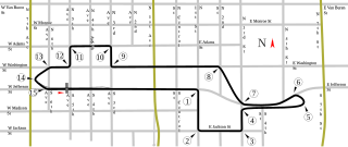
English: Track map for Phoenix street circuit. This version applies only to 1991. The track changed that year. For the version of the track as of 1989-1990, please see Image:Phoenix Grand Prix Route - 1989, 1990.svg (below). |
| Date | |
| Source | Own work |
| Author | Will Pittenger |
| Other versions |
|


| Camera location | | View this and other nearby images on: OpenStreetMap |
|---|
Licensing
| I, the copyright holder of this work, release this work into the public domain. This applies worldwide. In some countries this may not be legally possible; if so: I grant anyone the right to use this work for any purpose, without any conditions, unless such conditions are required by law. |
File history
Click on a date/time to view the file as it appeared at that time.
| Date/Time | Dimensions | User | Comment | |
|---|---|---|---|---|
| current | 01:50, 25 July 2008 | 1,818 × 764 (334 KB) | Will Pittenger | MediaWiki/RSVG and Firefox 3.0 were both showing the vertical text horizontally. This version fixes that by converting such text objects into paths. Important: If you need to edit this SVG, please use the previous version. |
File usage
The following page uses this file: