File:PopulationDensityYellowSea.png
No higher resolution available.
PopulationDensityYellowSea.png (323 × 342 pixels, file size: 54 KB, MIME type: image/png)
| This is a file from the Wikimedia Commons. The description on its description page there is shown below.
|
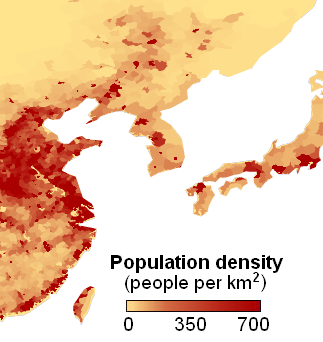
| Description | Population density around the Yellow Sea area | ||
| Date | (UTC) | ||
| Source | |||
| Author |
|
||
| Other versions |
|

| This file is in the public domain in the United States because it was solely created by NASA. NASA copyright policy states that "NASA material is not protected by copyright unless noted". (See Template:PD-USGov, NASA copyright policy page or JPL Image Use Policy.) | ||
 |
Warnings:
|
Original upload log
This image is a derivative work of the following images:
- File:Population_density.png licensed with PD-USGov-NASA
- 2007-02-27T03:41:42Z Keenan Pepper 4320x2160 (936888 Bytes) This image shows the number of people per square kilometer around the world in 1994. The data were derived from population records based on political divisions such as states, provinces, and counties. The image was taken fro
Uploaded with derivativeFX
File history
Click on a date/time to view the file as it appeared at that time.
| Date/Time | Dimensions | User | Comment | |
|---|---|---|---|---|
| current | 02:36, 7 September 2010 | 323 × 342 (54 KB) | Materialscientist | {{Information |Description= |Source=*File:Population_density.png |Date=2010-09-07 09:36 (UTC) |Author=*File:Population_density.png: created by NASA *derivative work: ~~~ |Permission= |other_versions= }} {{self|PD-USGov-NASA}} == |
File usage
The following page uses this file: