File:Population density of Africa.jpg
Size of this preview: 650 × 600 pixels. Other resolutions: 260 × 240 pixels | 520 × 480 pixels | 738 × 681 pixels.
Original file (738 × 681 pixels, file size: 84 KB, MIME type: image/jpeg)
| This is a file from the Wikimedia Commons. The description on its description page there is shown below.
|


Summary
| Description |
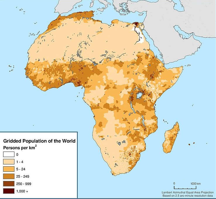
English: Map showing the population density of Africa. Title: Africa: Population Density, 2000 |
| Date | |
| Source | http://sedac.ciesin.columbia.edu/data/set/gpw-v3-population-density/maps |
| Author |
Center for International Earth Science Information Network - CIESIN - Columbia University, International Food Policy Research Institute - IFPRI, The World Bank, and Centro Internacional de Agricultura Tropical - CIAT. 2011. Global Rural-Urban Mapping Project, Version 1 (GRUMPv1): Urban Extents Grid (Africa). Palisades, NY: NASA Socioeconomic Data and Applications Center (SEDAC). http://sedac.ciesin.columbia.edu/data/set/grump-v1-urban-extents/maps. Accessed 12 October 2017. Source: Center for International Earth Science Information Network (CIESIN), Columbia University; and Centro Internacional de Agricultura Tropical (CIAT), Gridded Population of the World (GPW), Version 3. Palisades, NY: CIESIN, Columbia University. Available at: http://sedac.ciesin.columbia.edu/gpw." |
| Permission (Reusing this file) |
CC BY 3.0. See the previous versions of this file. |
Licensing
This file is licensed under the Creative Commons Attribution 3.0 Unported license.
- You are free:
- to share – to copy, distribute and transmit the work
- to remix – to adapt the work
- Under the following conditions:
- attribution – You must give appropriate credit, provide a link to the license, and indicate if changes were made. You may do so in any reasonable manner, but not in any way that suggests the licensor endorses you or your use.
File history
Click on a date/time to view the file as it appeared at that time.
| Date/Time | Dimensions | User | Comment | |
|---|---|---|---|---|
| current | 08:02, 18 December 2017 | 738 × 681 (84 KB) | Maproom | Removed credits, logos, etc. Lengthened scale. |
File usage
The following page uses this file: