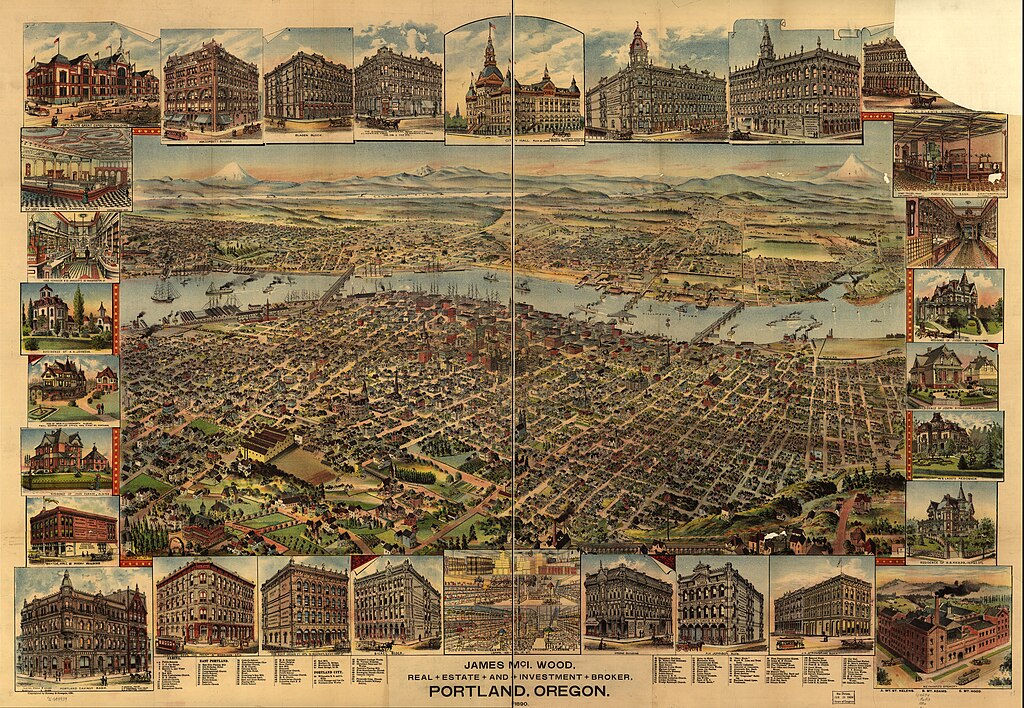
File:Portland, Oregon 1890 Perspective Birds-eye-view Map.jpg

Size of this preview: 800 × 553 pixels. Other resolutions: 320 × 221 pixels | 640 × 443 pixels | 1,024 × 708 pixels | 1,280 × 886 pixels | 13,760 × 9,520 pixels.
Original file (13,760 × 9,520 pixels, file size: 35.12 MB, MIME type: image/jpeg)
| This is a file from the Wikimedia Commons. The description on its description page there is shown below.
|
Summary
| Description |
English: Portland, Oregon 1890 Perspective Birds-eye-view Map |
| Date | |
| Source | https://www.loc.gov/resource/g4294p.pm007240/?st=image&r=-0.111,0.057,1.251,0.769,0 |
| Author | Library of Congress, Geography and Map Division |
Licensing
This work is in the public domain in the United States because it was published (or registered with the U.S. Copyright Office) before January 1, 1929.
Public domain works must be out of copyright in both the United States and in the source country of the work in order to be hosted on the Commons. If the work is not a U.S. work, the file must have an additional copyright tag indicating the copyright status in the source country.
Note: This tag should not be used for sound recordings. |
This work is in the public domain in the United States because it is a work prepared by an officer or employee of the United States Government as part of that person’s official duties under the terms of Title 17, Chapter 1, Section 105 of the US Code.
Note: This only applies to original works of the Federal Government and not to the work of any individual U.S. state, territory, commonwealth, county, municipality, or any other subdivision. This template also does not apply to postage stamp designs published by the United States Postal Service since 1978. (See § 313.6(C)(1) of Compendium of U.S. Copyright Office Practices). It also does not apply to certain US coins; see The US Mint Terms of Use.
|
 | |
| This file has been identified as being free of known restrictions under copyright law, including all related and neighboring rights. | ||
File history
Click on a date/time to view the file as it appeared at that time.
| Date/Time | Dimensions | User | Comment | |
|---|---|---|---|---|
| current | 12:06, 6 January 2024 | 13,760 × 9,520 (35.12 MB) | Cuyamas | Uploaded a work by Library of Congress, Geography and Map Division from https://www.loc.gov/resource/g4294p.pm007240/?st=image&r=-0.111,0.057,1.251,0.769,0 with UploadWizard |
File usage
The following page uses this file: