File:Rail gauge world.svg

Size of this PNG preview of this SVG file: 800 × 406 pixels. Other resolutions: 320 × 162 pixels | 640 × 325 pixels | 1,024 × 520 pixels | 1,280 × 650 pixels | 2,754 × 1,398 pixels.
Original file (SVG file, nominally 2,754 × 1,398 pixels, file size: 1.05 MB)
| This is a file from the Wikimedia Commons. The description on its description page there is shown below.
|
Summary
| Description |
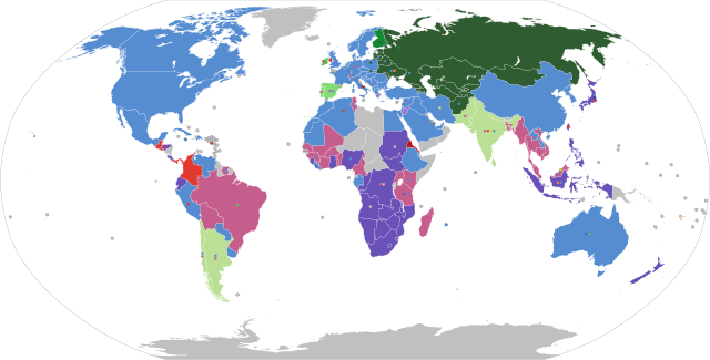
English: Shows the railroad gauge which is currently most used in each country (main colour), with other significant gauges used depicted as small squares on top of the main colour. Grey indicates no railways.
Español: Muestra el ancho de vía más comunmente usado en cada país (color principal), con otros anchos representados con pequeños cuadrados sobre el color principal. El color gris indica que no existen vías férreas en el territorio.
Français : Montre l'écartement le plus utilisé dans chaque pays (couleur principale), les autres écartements significatifs sont illustrés par des petits carrés superposés sur la couleur principale. Le gris indique l'absence de chemins de fer.
Русский: Ширина колеи железных дорог, используемая в настоящее время наиболее часто в разных странах (основной цвет). Прочие используемые ширины колеи изображены в виде маленьких квадратиков поверх основного цвета. Серый цвет — отсутствие железных дорог.
中文:图中各国的主色表示该国最通用的铁路轨距,小色块代表其他重要的轨距,灰色则为尚无铁路的国家 |
| Map legend |
597 mm, 600 mm, 603 mm, 610 mm (Two foot)
750 mm, 760 mm Bosnian, 762 mm (Two foot six inch), 800 mm
891 mm Swedish, 900 mm, 914 mm (Three foot)
1000 mm (Metre)
1067 mm (Three foot six inch)
1372 mm (Four foot six inch)
1435 mm Standard
1520 mm Russian standard
1524 mm Old Russian standard (Five foot)
1600 mm (Five foot three inch)
1668 mm Iberian
1676 mm Indian (Five foot six inch)
1829 mm (Six foot), 2140 mm Brunel |
| SVG development | |
| Date | |
| Source | Made using the list on CIA Factbook railways, Seabhcan's railmap and OpenRailwayMap. Uses BlankMap-World.svg |
| Creator |
selfmade |
| Georeferencing | If inappropriate please set warp_status = skip to hide. |
| Other versions | PNG version (outdated), SVG version with legend (current) |


Licensing
I, the copyright holder of this work, hereby publish it under the following license:

|
Permission is granted to copy, distribute and/or modify this document under the terms of the GNU Free Documentation License, Version 1.2 or any later version published by the Free Software Foundation; with no Invariant Sections, no Front-Cover Texts, and no Back-Cover Texts. A copy of the license is included in the section entitled GNU Free Documentation License. |
| This file is licensed under the Creative Commons Attribution-Share Alike 3.0 Unported license. | ||
| ||
| This licensing tag was added to this file as part of the GFDL licensing update. |
File history
Click on a date/time to view the file as it appeared at that time.
| Date/Time | Dimensions | User | Comment | |
|---|---|---|---|---|
| current | 15:55, 19 January 2024 | 2,754 × 1,398 (1.05 MB) | Rtfroot | Mauritius metro (1435mm), Indonesia high speed line (1435mm) |
File usage
The following page uses this file: