File:RelayMineNo3.jpg
No higher resolution available.
RelayMineNo3.jpg (736 × 437 pixels, file size: 103 KB, MIME type: image/jpeg)
| This is a file from the Wikimedia Commons. The description on its description page there is shown below.
|
Summary
| Description |
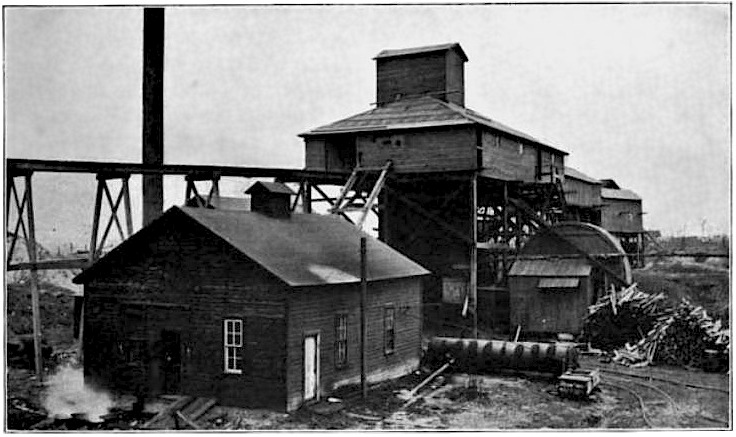
English: Original caption: "The upper works of the Relay Mine No. 3, Centerville, IA. The house in the foreground contains the hoisting engines. The shaft is in the center. The drum-like structure on the right is the fan which ventilates the mine. The trestle running to the left is for carrying away the refuse. The end of the dump pile shows just beyond the trestle. The weighing and storage sheds are beyond the shaft." |
| Date | |
| Source | An Iowa Coal Mine, Chapter V of Out of Door Studies in Geography, I, The Making of the Surface and Soils of the Upper Mississippi Region |
| Author | Francis M. Fultz (1857-1948) |
| Camera location | | View this and other nearby images on: OpenStreetMap |
|---|
location estimated from map file:CentervilleMines.png where this is known to be mine number 31, and refined using the more accurate map at the end of H. Foster Bain, Geology of Appanoose County, Iowa Geological Survey Annual Report, 1895, where it is marked as number 3.
Licensing
This media file is in the public domain in the United States. This applies to U.S. works where the copyright has expired, often because its first publication occurred prior to January 1, 1929, and if not then due to lack of notice or renewal. See this page for further explanation.
|
 | |
 |
This image might not be in the public domain outside of the United States; this especially applies in the countries and areas that do not apply the rule of the shorter term for US works, such as Canada, Mainland China (not Hong Kong or Macao), Germany, Mexico, and Switzerland. The creator and year of publication are essential information and must be provided. See Wikipedia:Public domain and Wikipedia:Copyrights for more details.
|
File history
Click on a date/time to view the file as it appeared at that time.
| Date/Time | Dimensions | User | Comment | |
|---|---|---|---|---|
| current | 08:01, 15 September 2009 | 736 × 437 (103 KB) | Douglas W. Jones | {{Information |Description={{en|1=Original caption" The upper works of the Relay Mine No. 3, Centerville, IA. The house in the foreground contains the hoisting engines. The shaft is in the center. The drum-like structure on the right is the fan which |
File usage
The following page uses this file: