File:Riodelaplatabasinmap.png

Size of this preview: 596 × 600 pixels. Other resolutions: 238 × 240 pixels | 477 × 480 pixels | 763 × 768 pixels | 1,017 × 1,024 pixels | 1,500 × 1,510 pixels.
Original file (1,500 × 1,510 pixels, file size: 3.14 MB, MIME type: image/png)
| This is a file from the Wikimedia Commons. The description on its description page there is shown below.
|
Summary
| Description |
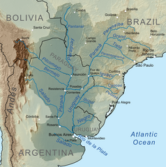
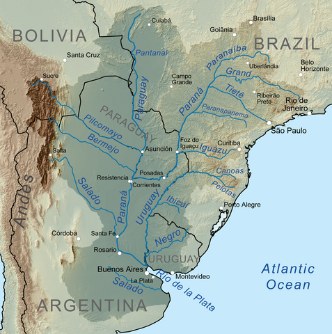
English: Map showing the Río de la Plata drainage basin including major tributaries and cities.
Español: Mapa que muestra la cuenca de drenaje del Río de la Plata, incluidos los principales afluentes y ciudades. |
| Date | |
| Source | Own work, Elevation data from SRTM, drainage basin from GTOPO [1], all other features from Vector Map. |
| Author | Kmusser |
| Other versions |
|


Licensing
I, the copyright holder of this work, hereby publish it under the following license:
This file is licensed under the Creative Commons Attribution-Share Alike 3.0 Unported license.
- You are free:
- to share – to copy, distribute and transmit the work
- to remix – to adapt the work
- Under the following conditions:
- attribution – You must give appropriate credit, provide a link to the license, and indicate if changes were made. You may do so in any reasonable manner, but not in any way that suggests the licensor endorses you or your use.
- share alike – If you remix, transform, or build upon the material, you must distribute your contributions under the same or compatible license as the original.
File history
Click on a date/time to view the file as it appeared at that time.
| Date/Time | Dimensions | User | Comment | |
|---|---|---|---|---|
| current | 09:43, 6 October 2010 | 1,500 × 1,510 (3.14 MB) | Kmusser | == Summary == {{Information |Description=Map showing the Río de la Plata drainage basin including major tributaries and cities. |Source={{own}}, Elevation data from SRTM, drainage basin from |
File usage
The following 6 pages use this file: