File:River Thames at Isleworth Ait - geograph.org.uk - 535417.jpg
No higher resolution available.
River_Thames_at_Isleworth_Ait_-_geograph.org.uk_-_535417.jpg (640 × 480 pixels, file size: 129 KB, MIME type: image/jpeg)
| This is a file from the Wikimedia Commons. The description on its description page there is shown below.
|
Summary
| Description |
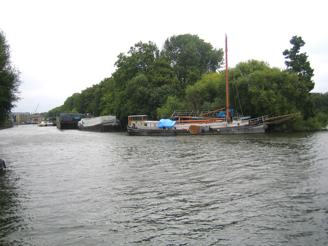
English: River Thames at Isleworth Ait Isleworth Ait is one of several islands in this reach of the River Thames. The 3.5 hectare island is uninhabited and only accessible by boat. It is a Local Nature Reserve (LNR) managed by the London Wildlife Trust, and their website page describing the island and its natural habitat is here http://www.wildlondon.org.uk/reserve.php?reserve_id=95 The whole of the island is contained within this grid square, and this is the southern or upstream tip.
The "paddle" on the side of the boat moored on the island is a leeboard, which is a type of keel that can be lowered into the water to provide sideways stability whilst the vessel is under away. |
| Date | |
| Source | From geograph.org.uk |
| Author | Nigel Cox |
| Attribution (required by the license) | Nigel Cox / River Thames at Isleworth Ait / |
| Camera location | | View this and other nearby images on: OpenStreetMap |
|---|
_heading:45.00&language=en)
| Object location | | View this and other nearby images on: OpenStreetMap |
|---|
_heading:45.00&language=en)
Licensing

|
This image was taken from the Geograph project collection. See this photograph's page on the Geograph website for the photographer's contact details. The copyright on this image is owned by Nigel Cox and is licensed for reuse under the Creative Commons Attribution-ShareAlike 2.0 license.
|
This file is licensed under the Creative Commons Attribution-Share Alike 2.0 Generic license.
Attribution: Nigel Cox
- You are free:
- to share – to copy, distribute and transmit the work
- to remix – to adapt the work
- Under the following conditions:
- attribution – You must give appropriate credit, provide a link to the license, and indicate if changes were made. You may do so in any reasonable manner, but not in any way that suggests the licensor endorses you or your use.
- share alike – If you remix, transform, or build upon the material, you must distribute your contributions under the same or compatible license as the original.
File history
Click on a date/time to view the file as it appeared at that time.
| Date/Time | Dimensions | User | Comment | |
|---|---|---|---|---|
| current | 13:51, 5 February 2011 | 640 × 480 (129 KB) | GeographBot | == {{int:filedesc}} == {{Information |description={{en|1=River Thames at Isleworth Ait Isleworth Ait is one of several islands in this reach of the River Thames. The 3.5 hectare island is uninhabited and only accessible by boat. It is a Local Nature Reser |
File usage
The following page uses this file: