File:Rom1793-1812.png
No higher resolution available.
Rom1793-1812.png (587 × 413 pixels, file size: 78 KB, MIME type: image/png)
| This is a file from the Wikimedia Commons. The description on its description page there is shown below.
|


|
This map image could be re-created using vector graphics as an SVG file. This has several advantages; see Commons:Media for cleanup for more information. If an SVG form of this image is available, please upload it and afterwards replace this template with
{{vector version available|new image name}}.
It is recommended to name the SVG file “Rom1793-1812.svg”—then the template Vector version available (or Vva) does not need the new image name parameter. |
Summary
| Description |
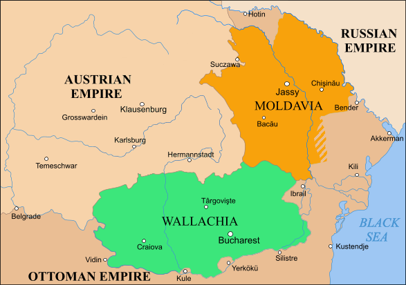
English: Moldavia, Wallachia and Transylvania between the Second Partition of Poland, 1793 and the Treaty of Bucharest, 1812 |
| Source | |
| Author |
Licensing
| This file is licensed under the Creative Commons Attribution-Share Alike 3.0 Unported license. Subject to disclaimers. | ||
| ||
| This licensing tag was added to this file as part of the GFDL licensing update. |

|
Permission is granted to copy, distribute and/or modify this document under the terms of the GNU Free Documentation License, Version 1.2 or any later version published by the Free Software Foundation; with no Invariant Sections, no Front-Cover Texts, and no Back-Cover Texts. A copy of the license is included in the section entitled GNU Free Documentation License. Subject to disclaimers. |

|
File:Danubian Principalities 1800.svg is a vector version of this file. It should be used in place of this PNG file when not inferior.
File:Rom1793-1812.png → File:Danubian Principalities 1800.svg
For more information, see Help:SVG. |
 |
File history
Click on a date/time to view the file as it appeared at that time.
| Date/Time | Dimensions | User | Comment | |
|---|---|---|---|---|
| current | 05:49, 8 October 2023 | 587 × 413 (78 KB) | Gyalu22 | Transylvania was part of the Austrian Empire |
File usage
The following page uses this file: