File:Ruhrtalbruecke-Sonnenuntergang.jpg

Original file (2,904 × 1,923 pixels, file size: 3.97 MB, MIME type: image/jpeg)
| This is a file from the Wikimedia Commons. The description on its description page there is shown below.
|
Summary
| Description |
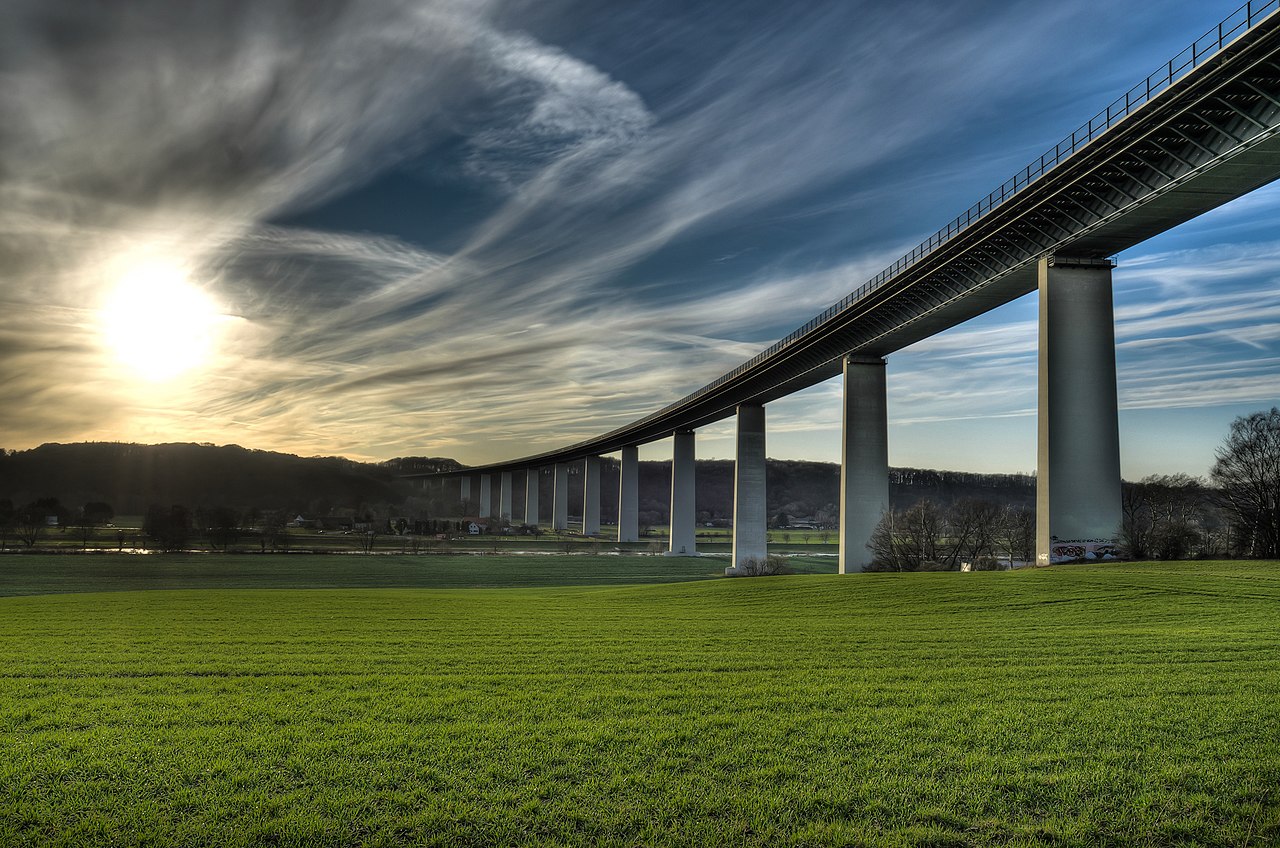
English: The bridge "Mintarder Ruhrtalbrücke" in Mülheim an der Ruhr is an impressive landmark in the Ruhr valley connecting the cities Düsseldorf and Essen through a motorway.
Deutsch: Die Mintarder Ruhrtalbrücke ist eine imposante Landschaftsmarke und verbindet über die A52 die Städte Düsseldorf und Essen.
Español: El puente Mintarder Ruhrtalbrücke, en la villa de Mülheim an der Ruhr, es una impresionante estructura construida sobre el valle del Ruhr que conecta las ciudades de Düsseldorf y Essen con una autopista, la 52.
Français : Le pont Mintarder Ruhrtalbrücke à Mülheim an der Ruhr est une structure impressionnante dans la vallée de la Ruhr, reliant les villes de Düsseldorf et de Essen par l'autoroute 52.
Italiano: Il ponte "Mintarder Ruhrtalbrücke" a Mülheim an der Ruhr è un impressionate manufatto della valle del Ruhr che connette le città di Düsseldorf e Essen. |
| Date | |
| Source | Own work |
| Author | Tuxyso |
| Other versions | Derivative works of this file: Ruhrtalbruecke-Sonnenuntergang banner.jpg |
| Attribution (required by the license) | Tuxyso / Wikimedia Commons / |
| Camera location | | View this and other nearby images on: OpenStreetMap |
|---|
| Object location | | View this and other nearby images on: OpenStreetMap |
|---|

|
NOTE: This image is a panorama of "HDR of a backlight situation" consisting of 7 frames that were merged or stitched in "Photomatix". As a result, this image necessarily underwent some form of digital manipulation. These manipulations may include blending, blurring, cloning, and colour and perspective adjustments. As a result of these adjustments, the image content may be slightly different from reality at the points where multiple images were combined. This manipulation is often required due to lens, perspective, and parallax distortions.
|
Assessment
|

This image was selected as picture of the day on Wikimedia Commons for 7 April 2013. It was captioned as follows: English: The bridge "Mintarder Ruhrtalbrücke" in Mülheim an der Ruhr is an impressive landmark in the Ruhr valley connecting the cities Düsseldorf and Essen through a motorway. Other languages:
Deutsch: Die Mintarder Ruhrtalbrücke ist eine imposante Landschaftsmarke und verbindet über die A52 die Städte Düsseldorf und Essen English: The bridge "Mintarder Ruhrtalbrücke" in Mülheim an der Ruhr is an impressive landmark in the Ruhr valley connecting the cities Düsseldorf and Essen through a motorway. Français : Le pont Mintarder Ruhrtalbrücke dans la ville de Mülheim an der Ruhr est un ouvrage impressionnant de la vallée de la Ruhr. Il relie les villes de Düsseldorf et de Essen par l′autoroute 52. Italiano: Il ponte "Mintarder Ruhrtalbrücke" a Mülheim an der Ruhr è un impressionate manufatto della valle del Ruhr che connette le città di Düsseldorf e Essen. Magyar: A "Mintarder Ruhrtalbrücke", Németország leghosszabb (1830 m-es), acélból készült közúti hídja az Essent és Düsseldorfot összekötő A52-es autópálya része Nederlands: De "Mintarder Ruhrtalbrücke" bij Mülheim an der Ruhr over de Ruhrvallei is een viaduct dat de steden Düsseldorf en Essen middels een autoweg met elkaar verbindt. Русский: Виадук через Рур к югу от Мюльхайма в лучах заходящего Солнца. Українська: Міст Mintarder Ruhrtalbrücke у Мюльгайм-ан-дер-Рур – вражаюча пам'ятка в долині річки Рур, що сполучає автомагістралями міста Дюссельдорф та Ессен. 中文: 敏塔德·鲁尔河谷桥是德国米尔海姆一个地标性建筑,52号公路通过该桥。 |
Licensing
- You are free:
- to share – to copy, distribute and transmit the work
- to remix – to adapt the work
- Under the following conditions:
- attribution – You must give appropriate credit, provide a link to the license, and indicate if changes were made. You may do so in any reasonable manner, but not in any way that suggests the licensor endorses you or your use.
- share alike – If you remix, transform, or build upon the material, you must distribute your contributions under the same or compatible license as the original.
|
Dieses Foto ist vom Wikimedia Commons Nutzer Tuxyso. Achtung: Dieses Bild ist nicht gemeinfrei. Es ist zwar frei benutzbar aber gesetzlich geschützt. |
This photo was created by Wikimedia Commons user Tuxyso. Note: this image is not in the Public Domain. It is free to use but protected by law. |
||
|
|
Bitte benutzen sie nach Möglichkeit in der Bildbeschreibung: Tuxyso / Wikimedia Commons / CC-BY-SA-3.0 in unmittelbarer Nähe beim Bild oder an einer Stelle in ihrer Publikation, wo dies üblich ist. Dabei muß der Zusammenhang zwischen Bild und Urhebernennung gewahrt bleiben. |
I prefer the following credit: Tuxyso / Wikimedia Commons / CC-BY-SA-3.0 near to the photo or at a location that is common in your publication but preserving the association between image and credit. |
 |
|
Bitte lesen sie den Lizenztext gründlich, bevor sie das Bild nutzen! Wenn sie Fragen zu den Lizenzvereinbarungen haben oder mich auf eine interessante Nachnutzung hinweisen möchten, kontaktieren sie mich bitte per Mail: tuxyso@gmail.com. |
Please review the license requirements carefully before using this image. If you would like to clarify the license terms or inform me about a reuse of the image (which is always interesting for me), please contact me by email: tuxyso@gmail.com. |
||

This image has been assessed using the Quality image guidelines and is considered a Quality image.
|
File history
Click on a date/time to view the file as it appeared at that time.
| Date/Time | Dimensions | User | Comment | |
|---|---|---|---|---|
| current | 06:06, 12 November 2012 | 2,904 × 1,923 (3.97 MB) | Tuxyso | Tilted and sharpened a bit |
File usage
The following page uses this file: