File:Seegewässer Philippinen 1.svg

Original file(SVG file, nominally 1,223 × 743 pixels, file size: 623 KB)

Commons-logo.svg This is a file from the Wikimedia Commons. The description on its description page there is shown below.
Commons is a freely licensed media file repository. You can help.

Summary

Description
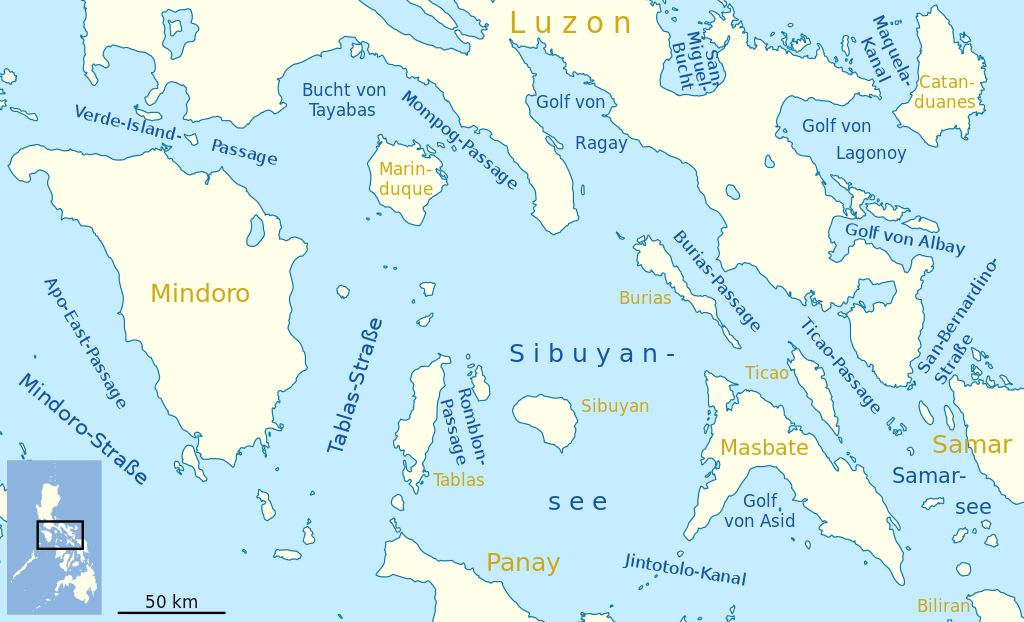
Deutsch: Karte der Seegewässer der Philippinen, Teil Sibuyansee
English: Map of seas of the Philippines, Sibuyan Sea area
Date
Source Own work, using United States National Imagery and Mapping Agency data
Author NordNordWest
Permission
(Reusing this file)

I have published this file as author NordNordWest under the "CC-BY-SA-3.0-DE" in Wikipedia. This means that free, commercial usage outside of Wikipedia is permitted under the following licence terms:

Please send me a specimen copy or the URL of the website where the file is used.

Please write an email to nnwest[at]web.de if you

  • need my postal address for sending a specimen copy
  • have further questions about the terms of the licence

PS: In case of refusal of the above terms the author reserves the right to take legal action.

w:en:Creative Commons
attribution share alike
This file is licensed under the Creative Commons Attribution-Share Alike 3.0 Germany license.
You are free:
  • to share – to copy, distribute and transmit the work
  • to remix – to adapt the work
Under the following conditions:
  • attribution – You must give appropriate credit, provide a link to the license, and indicate if changes were made. You may do so in any reasonable manner, but not in any way that suggests the licensor endorses you or your use.
  • share alike – If you remix, transform, or build upon the material, you must distribute your contributions under the same or compatible license as the original.
w:en:Creative Commons
attribution share alike
This file is licensed under the Creative Commons Attribution-Share Alike 3.0 Unported license.
You are free:
  • to share – to copy, distribute and transmit the work
  • to remix – to adapt the work
Under the following conditions:
  • attribution – You must give appropriate credit, provide a link to the license, and indicate if changes were made. You may do so in any reasonable manner, but not in any way that suggests the licensor endorses you or your use.
  • share alike – If you remix, transform, or build upon the material, you must distribute your contributions under the same or compatible license as the original.
Kartenwerkstatt
This map has been made or improved in the German Kartenwerkstatt (Map Lab). You can propose maps to improve as well.

Captions

Add a one-line explanation of what this file represents

Items portrayed in this file

depicts

16 February 2011

637,763 byte

743 pixel

1,223 pixel

image/svg+xml

6436518c67e98add43e879aecb88301530861ec8

File history

Click on a date/time to view the file as it appeared at that time.

Date/TimeDimensionsUserComment
current12:14, 16 February 20111,223 × 743 (623 KB)NordNordWest== {{int:filedesc}} == {{Information |Description= {{de|Karte der Seegewässer der Philippinen, Teil Sibuyansee}} {{en|Map of seas of the Philippines, Sibuyan Sea area}} |Source={{Own}}, using United States National Imagery and Mapping Agency data |Date=

The following page uses this file: