File:Serbia1918.png
Size of this preview: 370 × 600 pixels. Other resolutions: 148 × 240 pixels | 586 × 950 pixels.
Original file (586 × 950 pixels, file size: 60 KB, MIME type: image/png)
| This is a file from the Wikimedia Commons. The description on its description page there is shown below.
|
Summary
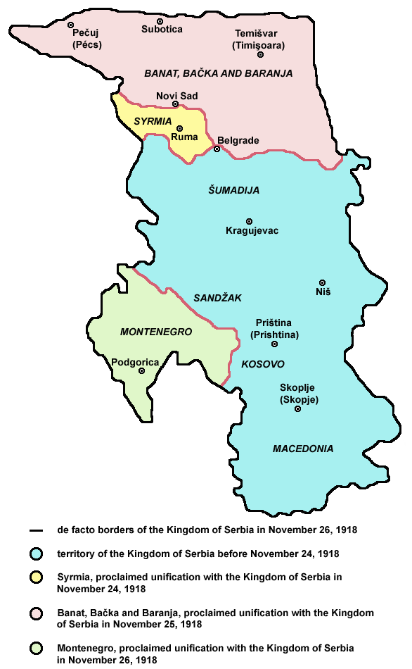
- English: de facto borders of the Kingdom of Serbia in November 26, 1918, after unification with Syrmia (November 24), Banat, Bačka and Baranja (November 25) and Montenegro (November 26), during the process of Creation of Yugoslavia.
- Serbian: фактичке границе Краљевине Србије 26. новембра 1918. године, после уједињења са Сремом (24. новембра), Банатом, Бачком и Барањом (25. новембра) и Црном Гором (26. новембра), током процеса стварања Југославије.

|
This image could be re-created using vector graphics as an SVG file. This has several advantages; see Commons:Media for cleanup for more information. If an SVG form of this image is available, please upload it and afterwards replace this template with
{{vector version available|new image name}}.It is recommended to name the SVG file “Serbia1918.svg”—then the template Vector version available (or Vva) does not need the new image name parameter. |
References
Published references:
- Drago Njegovan, Prisajedinjenje Vojvodine Srbiji, Novi Sad, 2004.
- Drago Njegovan, Prisajedinjenje Srema, Banata, Bačke i Baranje Srbiji 1918. - dokumenti i prilozi, Novi Sad, 2001.
- Lazo M. Kostić, Srpska Vojvodina i njene manjine, Novi Sad, 1999.
- Dimitrije Boarov, Politička istorija Vojvodine, Novi Sad, 2001.
- Dr Tomislav Bogavac, Nestajanje Srba, Niš, 1994.
- Čedomir Popov - Jelena Popov, Autonomija Vojvodine - srpsko pitanje, Sremski Karlovci, 2000.
- Rade Šumonja, Spomenica oslobođenja Sombora 1918-1998, Sombor, 1998.
Internet references:
- Map archive copy at the Wayback Machine
- Map
- Map archive copy at the Wayback Machine
Licensing

|
This map has been uploaded by Electionworld from en.wikipedia.org to enable the |
Self-made map by WikiEditor2004
| This work has been released into the public domain by its author, WikiEditor2004. This applies worldwide. In some countries this may not be legally possible; if so: |
File history
Click on a date/time to view the file as it appeared at that time.
| Date/Time | Dimensions | User | Comment | |
|---|---|---|---|---|
| current | 01:48, 24 December 2009 | 586 × 950 (60 KB) | WikiEditor2004 | aesthetics |
File usage
The following page uses this file: