File:Spitalfields rookery.jpg
No higher resolution available.
Spitalfields_rookery.jpg (800 × 417 pixels, file size: 459 KB, MIME type: image/jpeg)
| This is a file from the Wikimedia Commons. The description on its description page there is shown below.
|
| Description |
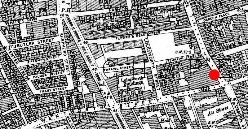
English: 1894 ordnance survey map of Whitechapel showing the area around en:Spitalfields where many common lodging-houses were situated in the late Victorian era. Red circle indicates the location at the junction of Osborn Street and en:Brick Lane near where en:Emma Elizabeth Smith (the first en:Whitechapel murders victim) was attacked. The building to the immediate west of the red circle is a chocolate factory. |
||||||
| Date | 1894, amended 2009 | ||||||
| Source | Original map downloaded from http://www.casebook.org/official_documents/map/images/ord_map_full.jpg | ||||||
| Author | Ordnance Survey, modified by uploader | ||||||
| Permission (Reusing this file) |
|
||||||
| Other versions | Cropped from File:Whitechapel murders.jpg |

File history
Click on a date/time to view the file as it appeared at that time.
| Date/Time | Dimensions | User | Comment | |
|---|---|---|---|---|
| current | 03:41, 4 December 2009 | 800 × 417 (459 KB) | DrKay | {{Information |Description={{en|1=1894 ordnance survey map of Whitechapel showing the area around en:Spitalfields where many common lodging-houses were situated in the late Victorian era. Red circle indicates the location at the junction of Osborn St |
File usage
The following page uses this file: