File:Spring Hill afternoon.png
Size of this preview: 490 × 599 pixels. Other resolutions: 196 × 240 pixels | 392 × 480 pixels | 491 × 600 pixels | 628 × 768 pixels | 837 × 1,024 pixels | 1,778 × 2,174 pixels.
Original file (1,778 × 2,174 pixels, file size: 697 KB, MIME type: image/png)
| This is a file from the Wikimedia Commons. The description on its description page there is shown below.
|
Summary
| Description |
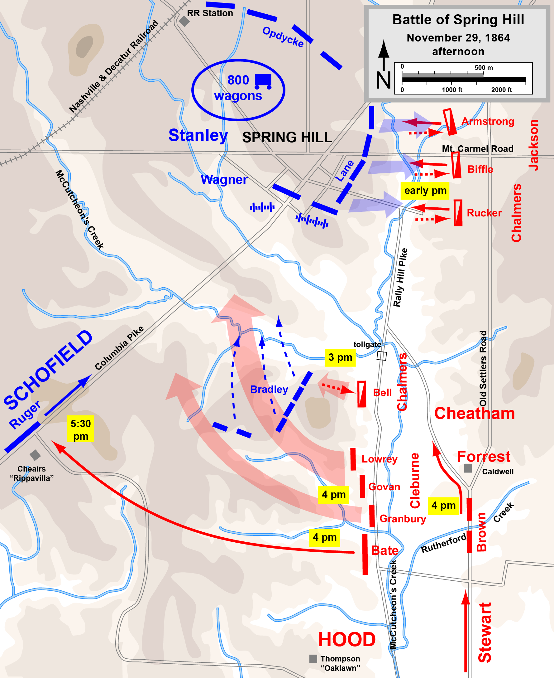
English: Map of the Battle of Spring Hill of the American Civil War: actions in the afternoon of November 29, 1864. |
| Date | |
| Source | Own work, derived from source http://www.posix.com/CWmaps/ (PD) |
| Author | Hal Jespersen |
Licensing
Hal Jespersen at en.wikipedia, the copyright holder of this work, hereby publishes it under the following license:
This file is licensed under the Creative Commons Attribution 3.0 Unported license.
Attribution:
Map by Hal Jespersen, www.posix.com/CW
- You are free:
- to share – to copy, distribute and transmit the work
- to remix – to adapt the work
- Under the following conditions:
- attribution – You must give appropriate credit, provide a link to the license, and indicate if changes were made. You may do so in any reasonable manner, but not in any way that suggests the licensor endorses you or your use.
Original upload log
The original description page was here. All following user names refer to en.wikipedia.
- 2009-12-08 01:35 Hlj 1778×2174× (603478 bytes) One more minor correction on name placements. Same license.
- 2009-12-08 01:27 Hlj 1778×2174× (602840 bytes) Corrected some unit locations. Same license.
- 2009-11-28 00:02 Hlj 1778×2174× (596199 bytes) {{Information |Description=Map of the [[Battle of Spring Hill]] of the [[American Civil War]]: actions in the afternoon of November 29, 1863. Drawn in Adobe Illustrator CS3 by Hal Jespersen. Graphic source file is available at http://www.posix.com/CWmaps/
File history
Click on a date/time to view the file as it appeared at that time.
| Date/Time | Dimensions | User | Comment | |
|---|---|---|---|---|
| current | 11:17, 17 March 2011 | 1,778 × 2,174 (697 KB) | Hlj | Minor graphical changes to conform to new ACW map style for roads and rivers. Same license. |
File usage
The following page uses this file: