File:Storm tide Bremerhaven 2013-12-06 (2).jpg

Size of this preview: 800 × 600 pixels. Other resolutions: 320 × 240 pixels | 640 × 480 pixels | 1,024 × 768 pixels | 1,280 × 960 pixels | 2,048 × 1,536 pixels.
Original file (2,048 × 1,536 pixels, file size: 773 KB, MIME type: image/jpeg)
| This is a file from the Wikimedia Commons. The description on its description page there is shown below.
|
.jpg)
Summary
| Description |
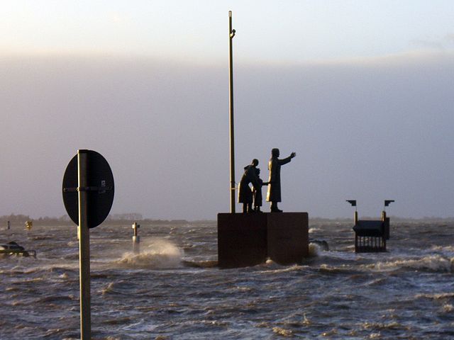
English: A monument to emigrants in Bremerhaven on a square near the Weser river, flooded by a storm tide caused by cyclone Bodil
Deutsch: Das Auswandererdenkmal auf dem Willy-Brandt-Platz in Bremerhaven während einer durch den Orkan Xaver ausgelösten Sturmflut |
| Date | |
| Source | Own work |
| Author | Tvabutzku1234 |
| Camera location | | View this and other nearby images on: OpenStreetMap |
|---|
.jpg¶ms=053.543836_N_0008.571328_E_globe:Earth_type:camera_heading:270.00&language=en)
Licensing
I, the copyright holder of this work, hereby publish it under the following license:
| This file is made available under the Creative Commons CC0 1.0 Universal Public Domain Dedication. | |
| The person who associated a work with this deed has dedicated the work to the public domain by waiving all of their rights to the work worldwide under copyright law, including all related and neighboring rights, to the extent allowed by law. You can copy, modify, distribute and perform the work, even for commercial purposes, all without asking permission.
|
File history
Click on a date/time to view the file as it appeared at that time.
| Date/Time | Dimensions | User | Comment | |
|---|---|---|---|---|
| current | 15:05, 6 December 2013 | 2,048 × 1,536 (773 KB) | Tvabutzku1234 | {{Information |Description ={{en|1=A monument to emigrants in Bremerhaven on a square near the Weser river, flooded by a storm tide caused by cyclone Bodil}} {{de|1=Das Auswandererdenkmal auf dem Willy-Brand... |
File usage
The following page uses this file:
.jpg)