File:TS Bonnie 2004.jpg

Size of this preview: 600 × 600 pixels. Other resolutions: 240 × 240 pixels | 480 × 480 pixels | 768 × 768 pixels | 1,024 × 1,024 pixels | 6,000 × 6,000 pixels.
Original file (6,000 × 6,000 pixels, file size: 6.81 MB, MIME type: image/jpeg)
| This is a file from the Wikimedia Commons. The description on its description page there is shown below.
|
Summary
| Description |
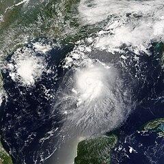
The MODIS instrument aboard NASA's Terra satellite captured this true-color image of Tropical Storm Bonnie on August 11 at 12:50 p.m. EDT. At the time this image was taken Bonnie had maximum sustained winds of 65 mph with an estimated minimum central pressure of 1000 millibars. Bonnie was expected to make landfall between Panama City and Apalachicola during the morning of August 12. The high-resolution image provided above has a spatial resolution of 1-square-kilometer per pixel. The MODIS Rapid Response System provides this image at additional resolutions and formats. |
|||||
| Date | ||||||
| Source | http://earthobservatory.nasa.gov/NaturalHazards/natural_hazards_v2.php3?img_id=12325 | |||||
| Author | Image courtesy Jacques Descloitres, MODIS Land Rapid Response Team at NASA GSFC. | |||||
| Permission (Reusing this file) |
|

File history
Click on a date/time to view the file as it appeared at that time.
| Date/Time | Dimensions | User | Comment | |
|---|---|---|---|---|
| current | 22:57, 30 July 2023 | 6,000 × 6,000 (6.81 MB) | Nino Marakot | Reverted to version as of 21:42, 19 August 2006 (UTC) |
File usage
The following page uses this file: