File:Exclusive Economic Zones - World.svg

Size of this PNG preview of this SVG file: 800 × 400 pixels. Other resolutions: 320 × 160 pixels | 640 × 320 pixels | 1,024 × 512 pixels | 1,280 × 640 pixels.
Original file (SVG file, nominally 800 × 400 pixels, file size: 694 KB)
| This is a file from the Wikimedia Commons. The description on its description page there is shown below.
|
Summary
| Description |
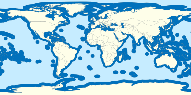
Español: Aguas territoriales del mundo. English: Territorial waters of the world. Français : Z.E.E. de chaque pays du monde. |
| Date | |
| Source |
Own work based on: World location map.svg Borders based on VLIZ Maritime boundaries and Internationalwaters.png |
| Author | B1mbo |
| SVG development |
Licensing
I, the copyright holder of this work, hereby publish it under the following license:
This file is licensed under the Creative Commons Attribution-ShareAlike 3.0 Chile license.
- You are free:
- to share – to copy, distribute and transmit the work
- to remix – to adapt the work
- Under the following conditions:
- attribution – You must give appropriate credit, provide a link to the license, and indicate if changes were made. You may do so in any reasonable manner, but not in any way that suggests the licensor endorses you or your use.
- share alike – If you remix, transform, or build upon the material, you must distribute your contributions under the same or compatible license as the original.

File history
Click on a date/time to view the file as it appeared at that time.
| Date/Time | Dimensions | User | Comment | |
|---|---|---|---|---|
| current | 02:22, 19 October 2023 | 800 × 400 (694 KB) | SyntaxTerror | Added Cyprus, many islands are missing (New Caledonia, Socotra, Jeju, Baleares, Caribean islands, islands in Hudson bay, etc.) |
File usage
There are no pages that use this file.