File:The Wash England.svg

Size of this PNG preview of this SVG file: 459 × 600 pixels. Other resolutions: 184 × 240 pixels | 367 × 480 pixels | 588 × 768 pixels | 783 × 1,024 pixels | 919 × 1,201 pixels.
Original file (SVG file, nominally 919 × 1,201 pixels, file size: 1.12 MB)
| This is a file from the Wikimedia Commons. The description on its description page there is shown below.
|
Summary
| Description |
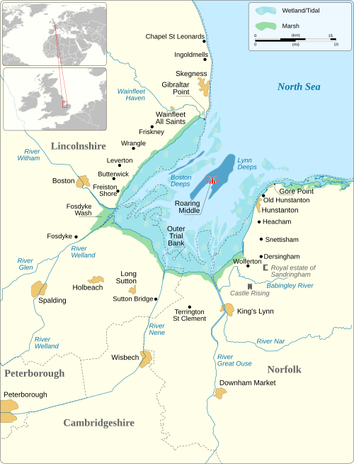
English: Map of The Wash, England.
|
||||||||||||||||||||||||||||||||||||||||||||||||||||||
| Date | |||||||||||||||||||||||||||||||||||||||||||||||||||||||
| Source |
Own work based on:
|
||||||||||||||||||||||||||||||||||||||||||||||||||||||
| Author | Goran_tek-en | ||||||||||||||||||||||||||||||||||||||||||||||||||||||
| Permission (Reusing this file) |
This file is licensed under the Creative Commons Attribution-Share Alike 4.0 International license. Attribution: Goran_tek-en
|
||||||||||||||||||||||||||||||||||||||||||||||||||||||
| Other versions |
|
||||||||||||||||||||||||||||||||||||||||||||||||||||||
| SVG development | |||||||||||||||||||||||||||||||||||||||||||||||||||||||


| Object location | | View this and other nearby images on: OpenStreetMap |
|---|

File history
Click on a date/time to view the file as it appeared at that time.
| Date/Time | Dimensions | User | Comment | |
|---|---|---|---|---|
| current | 07:36, 14 August 2025 | 919 × 1,201 (1.12 MB) | Goran tek-en | forgot Guyhirn |
File usage
The following page uses this file: