File:Tottenham, The Broadwater Farm Estate, N17 - geograph.org.uk - 235156.jpg
No higher resolution available.
Tottenham,_The_Broadwater_Farm_Estate,_N17_-_geograph.org.uk_-_235156.jpg (640 × 480 pixels, file size: 89 KB, MIME type: image/jpeg)
| This is a file from the Wikimedia Commons. The description on its description page there is shown below.
|
Summary
| Description |
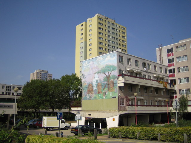
English: Tottenham: The Broadwater Farm Estate, N17. The estate was built between 1967 and 1973 in a style designed by Le Corbusier where no dwellings were at ground level because of the high water table of the Moselle River which is culverted under the estate. The warren of first floor concrete walkways offered opportunities for crime and anti-social behaviour and the consequent bad reputation of the estate long before the riot of 6 October 1985 which resulted in the murder of PC Keith Blakelock. Further information on the history of the estate can be found on Haringey Council's website here http://www.haringey.gov.uk/index/community_and_leisure/neighbourhoods/broadwaterfarm/historyofbroadwaterfarm.htm The mural is on the end wall of Rochford block and features Martin Luther King, Bob Marley, Mahatma Gandhi, and John Lennon. See 235530 for another photo of the estate in an adjacent grid square. |
| Date | |
| Source | From geograph.org.uk |
| Author | Nigel Cox |
| Attribution (required by the license) | Nigel Cox / Tottenham: The Broadwater Farm Estate, N17 / |
| Camera location | | View this and other nearby images on: OpenStreetMap |
|---|
_heading:315.00&language=en)
| Object location | | View this and other nearby images on: OpenStreetMap |
|---|
_heading:315.00&language=en)
Licensing

|
This image was taken from the Geograph project collection. See this photograph's page on the Geograph website for the photographer's contact details. The copyright on this image is owned by Nigel Cox and is licensed for reuse under the Creative Commons Attribution-ShareAlike 2.0 license.
|
This file is licensed under the Creative Commons Attribution-Share Alike 2.0 Generic license.
Attribution: Nigel Cox
- You are free:
- to share – to copy, distribute and transmit the work
- to remix – to adapt the work
- Under the following conditions:
- attribution – You must give appropriate credit, provide a link to the license, and indicate if changes were made. You may do so in any reasonable manner, but not in any way that suggests the licensor endorses you or your use.
- share alike – If you remix, transform, or build upon the material, you must distribute your contributions under the same or compatible license as the original.
File history
Click on a date/time to view the file as it appeared at that time.
| Date/Time | Dimensions | User | Comment | |
|---|---|---|---|---|
| current | 19:35, 31 January 2010 | 640 × 480 (89 KB) | GeographBot | == {{int:filedesc}} == {{Information |description={{en|1=Tottenham: The Broadwater Farm Estate, N17. The estate was built between 1967 and 1973 in a style designed by Le Corbusier where no dwellings were at ground level because of the high water table of |
File usage
The following page uses this file: