File:US-Population-Center-Illinois-and-Missouri.png

Size of this preview: 573 × 600 pixels. Other resolutions: 229 × 240 pixels | 639 × 669 pixels.
Original file (639 × 669 pixels, file size: 160 KB, MIME type: image/png)
| This is a file from the Wikimedia Commons. The description on its description page there is shown below.
|
Summary
| Description |
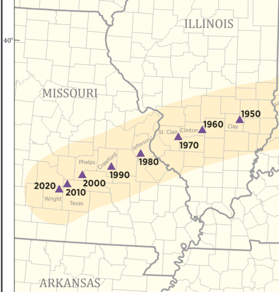
English: The mean center of the United States population from 1950 to 2020, as published by the U.S. Census bureau. In 1950 through 1970, the center was in the state of Illinois, but since 1980, the center has been in the state of Missouri. Published at: https://www.census.gov/library/visualizations/2020/geo/center-of-population-1790-2020.html |
| Date | |
| Source | https://www2.census.gov/geo/maps/DC2020/PopCenter/CenterPop_Mean_1790-2020.pdf |
| Author | Published by the U.S. Census bureau |
Licensing
This image or file is a work of a United States Census Bureau employee, taken or made as part of that person's official duties. As a work of the U.S. federal government, the image is in the public domain.
|
 |
File history
Click on a date/time to view the file as it appeared at that time.
| Date/Time | Dimensions | User | Comment | |
|---|---|---|---|---|
| current | 03:35, 23 November 2021 | 639 × 669 (160 KB) | RobLa | Uploaded a work by Published by the U.S. Census bureau from https://www2.census.gov/geo/maps/DC2020/PopCenter/CenterPop_Mean_1790-2020.pdf with UploadWizard |
File usage
There are no pages that use this file.