File:Urartu 715 713-en.svg

Size of this PNG preview of this SVG file: 800 × 513 pixels. Other resolutions: 320 × 205 pixels | 640 × 410 pixels | 1,024 × 657 pixels | 1,280 × 821 pixels | 2,714 × 1,740 pixels.
Original file (SVG file, nominally 2,714 × 1,740 pixels, file size: 881 KB)
| This is a file from the Wikimedia Commons. The description on its description page there is shown below.
|
Summary
| Description |
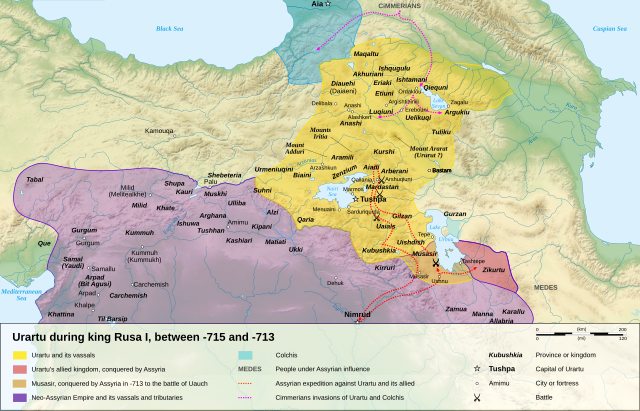
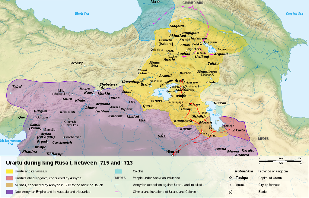
English: Map of the kingdom of Urartu, between -715 and -713.
Français : Carte en anglais du royaume d'Urartu, entre -715 et -713. |
||
| Date | |||
| Source |
Own work.
Sources :
Software used :
Other data :
|
||
| Author | Sémhur | ||
| Other versions |
See Urartu.
| ||
| Attribution (required by the license) | © Sémhur / Wikimedia Commons / | ||
| SVG | W3C-validity not checked.
|
||
| Atelier graphique |


| Camera location | | View this and other nearby images on: OpenStreetMap |
|---|
Licensing
I, the copyright holder of this work, hereby publish it under the following licenses:
| Copyleft: This work of art is free; you can redistribute it and/or modify it according to terms of the Free Art License. You will find a specimen of this license on the Copyleft Attitude site as well as on other sites. |
This file is licensed under the Creative Commons Attribution-Share Alike 4.0 International, 3.0 Unported, 2.5 Generic, 2.0 Generic and 1.0 Generic license.
- You are free:
- to share – to copy, distribute and transmit the work
- to remix – to adapt the work
- Under the following conditions:
- attribution – You must give appropriate credit, provide a link to the license, and indicate if changes were made. You may do so in any reasonable manner, but not in any way that suggests the licensor endorses you or your use.
- share alike – If you remix, transform, or build upon the material, you must distribute your contributions under the same or compatible license as the original.
You may select the license of your choice.
| Annotations | This image is annotated: View the annotations at Commons |
File history
Click on a date/time to view the file as it appeared at that time.
| Date/Time | Dimensions | User | Comment | |
|---|---|---|---|---|
| current | 09:15, 10 January 2008 | 2,714 × 1,740 (881 KB) | Sémhur | == Description == {{Information |Description= {{en| Map of the kingdom of Urartu, between -715 and -713.}} {{fr| Carte en anglais du royaume d'Urartu, entre -715 et -713.}} |Source=Own work. {{clr}} Sources : * Topographic background : [http://www2.jpl.na |
File usage
The following 3 pages use this file: