File:Urban two-storey wooden house.png

Size of this preview: 800 × 481 pixels. Other resolutions: 320 × 193 pixels | 640 × 385 pixels | 1,024 × 616 pixels | 1,280 × 770 pixels | 4,096 × 2,464 pixels.
Original file (4,096 × 2,464 pixels, file size: 3.78 MB, MIME type: image/png)
| This is a file from the Wikimedia Commons. The description on its description page there is shown below.
|
Summary
| DescriptionUrban two-storey wooden house.png |
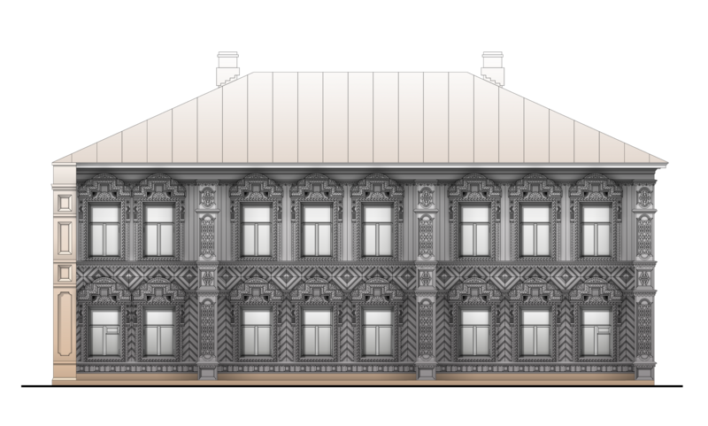
Русский: Этот двухэтажный дом расположен в Перми по адресу: ул. Клименко 14а. Он является типичным примером деревянной застройки Перми конца XIX - начала XX веков. Почти все деревянные дома в России являлись рублеными. Однако, расположение в городской черте обязывало дом иметь гладкие стены, поэтому большинство городских деревянных жилых домов обшиты профилированными досками. Широко используются накладные декоративные элементы и пропильная (сквозная) резьба. Кирпичная стена слева является противопожарной и предотвращает распространение огня в условиях плотной городской застройки. Определение исходного цвета фасада требует дополнительных натурных исследований, поэтому дом изображен в том цвете, который он имеет сейчас.
English: This house is located in Perm and is a typical example of the wooden buildings of Perm early XX century. Location home: 14a, Klimenko str. Absolute majority wooden houses in Russia are log hut. The house is planked with boards because it is located within the city limits. Widely used pierced work and overhead decorative elements. The paint on the facade was not preserved, so the house is shown in color, which he has now. On the left site is a wall of the bricks. It's fire division wall. Such walls prevented the spread of fire in dense development.
Italiano: Questa casa si trova a Perm. È un tipico esempio di edifici di legno a Perm inizi del XX secolo. Località casa: via Klimenko 14a. Quasi tutte case di legno in Russia sono costruite dei registri orizzontali. La casa ha intavolato perché si trova entro i confini della città. Ampiamente usato elementi decorativi. Il colore della facciata non è stato conservato, così la casa è mostrato in colore, che ora ha. A sinistra si trova un muro di mattoni. Questo è il muro tagliafiamma.
Polski: Ten dwukondygnacyjny dom położony przy ulicy Klimenko 14a w Permie jest przykładem typowej drewnianej zabudowy Permu z przełomu XIX i XX wieku. Prawie wszystkie drewniane domy w Rosji były domami z bali. Jednak lokalizacja w granicach miasta wymagała od domu gładkich ścian, dlatego większość drewnianej zabudowy mieszkalnej miasta jest obita deskami elewacyjnymi. Powszechnie stosowane były ażurowe zdobienia. Ceglany mur z lewej strony budynku jest ścianą przeciwogniową, która ma zapobiegać rozprzestrzenianiu się ognia w gęstej zabudowie miejskiej. Ustalenie pierwotnego koloru elewacji wymaga dodatkowych badań terenowych, dlatego dom jest przedstawiony w takim kolorze, jaki ma obecnie. |
|||||
| Date | ||||||
| Source | Own work | |||||
| Author | Wetlan (Владимир Литвинов / Vladimir Litvinov)]] | |||||
| Other versions |
|
| Camera location | 58° 00′ 56.71″ N, 56° 15′ 38.89″ E | View this and other nearby images on: OpenStreetMap |
|---|
Licensing
I, the copyright holder of this work, hereby publish it under the following license:
This file is licensed under the Creative Commons Attribution-Share Alike 4.0 International license.
- You are free:
- to share – to copy, distribute and transmit the work
- to remix – to adapt the work
- Under the following conditions:
- attribution – You must give appropriate credit, provide a link to the license, and indicate if changes were made. You may do so in any reasonable manner, but not in any way that suggests the licensor endorses you or your use.
- share alike – If you remix, transform, or build upon the material, you must distribute your contributions under the same or compatible license as the original.
Assessment
|

|
This image was selected as picture of the day on Wikimedia Commons for 26 November 2021. It was captioned as follows: English: Typical example of the wooden buildings of Perm early XX century. Location home: 14a, Klimenko str. Other languages:
English: Typical example of the wooden buildings of Perm early XX century. Location home: 14a, Klimenko str. Español: Imágen en formato de gráficos vectoriales escalables (SVG) de la fachada de una casa en Perm, Rusia. La casa esta ubicada en la calle Klimenko 14a y es un ejemplo típico de los edificios de madera de Perm de principios del siglo XX. Français : Immeuble en bois à Perm, début XXe siècle. Italiano: È un tipico esempio di edifici di legno a Perm inizi del XX secolo. Località casa: via Klimenko 14a. Magyar: A 20. század eleji permi faépületek tipikus példája. Ház a Klimenko utca 14a szám alatt (Oroszország) Português: Imagem em formato de gráficos vetoriais escaláveis (SVG) da fachada de uma casa em Perm, Rússia. A casa está localizada na rua Klimenko 14a e é um exemplo típico dos edifícios de madeira de Perm do início do século XX. Македонски: Типична дрвена градба во рускиот град Перм од почетокот на XX век Русский: Типичный пример деревянной застройки Перми конца XIX — начала XX веков. Адрес: ул. Клименко, дом № 14а. Українська: Типовий приклад дерев'яних будівель Пермі початку ХХ століття. Адреса будинку: вул. Клименка, 14а, Росія. |
Captions
Add a one-line explanation of what this file represents
Items portrayed in this file
depicts
some value
58°0'56.707"N, 56°15'38.894"E
23 November 2016
image/png
File history
Click on a date/time to view the file as it appeared at that time.
| Date/Time | Dimensions | User | Comment | |
|---|---|---|---|---|
| current | 10:50, 9 August 2023 | 4,096 × 2,464 (3.78 MB) | Obscure2020 | Optimized with OxiPNG and ZopfliPNG. |
File usage
The following page uses this file:


