File:View of Stans from NE.jpg
Size of this preview: 800 × 400 pixels. Other resolutions: 320 × 160 pixels | 640 × 320 pixels | 1,024 × 512 pixels | 1,280 × 640 pixels | 4,661 × 2,332 pixels.
Original file (4,661 × 2,332 pixels, file size: 4.92 MB, MIME type: image/jpeg)
This is a file from the Wikimedia Commons. The description on its description page there is shown below.
|
Summary
DescriptionView of Stans from NE.jpg |
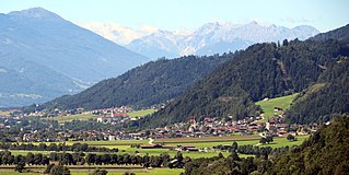
Deutsch: Stans gesehen von Nordosten (Jenbach). |
Date | |
Source | Own work |
Author | Braveheart |
Camera location | 47° 23′ 38.33″ N, 11° 45′ 56.22″ E | View this and other nearby images on: OpenStreetMap | 47.393980; 11.765618 |
---|
Licensing
I, the copyright holder of this work, hereby publish it under the following license:
This file is licensed under the Creative Commons Attribution-Share Alike 4.0 International license.
- You are free:
- to share – to copy, distribute and transmit the work
- to remix – to adapt the work
- Under the following conditions:
- attribution – You must give appropriate credit, provide a link to the license, and indicate if changes were made. You may do so in any reasonable manner, but not in any way that suggests the licensor endorses you or your use.
- share alike – If you remix, transform, or build upon the material, you must distribute your contributions under the same or compatible license as the original.
Diese Datei wurde im Rahmen von WikiDaheim 2017 in Österreich erstellt und hochgeladen. Sie wurde dem allgemeinen Themenbereich zugeordnet. |
The making of this work was supported by Wikimedia Austria. For other files made with the support of Wikimedia Austria, please see the category Supported by Wikimedia Österreich. |
Annotations InfoField | This image is annotated: View the annotations at Commons |
328
29
422
153
4661
2332
Patscherkofel
3969
284
255
146
4661
2332
Spitzmandl (2206m)
3328
240
131
124
4661
2332
Ampfer Stein (2556m)
2738
138
1617
73
4661
2332
Kalkkögel
1129
226
721
248
4661
2332
Stubaier Alpen
2061
379
182
95
4661
2332
Hoher Burgstall (2611m)
Items portrayed in this file
depicts
47°23'38.328"N, 11°45'56.225"E
13 August 2016
File history
Click on a date/time to view the file as it appeared at that time.
Date/Time | Dimensions | User | Comment | |
---|---|---|---|---|
current | 03:40, 4 October 2017 | 4,661 × 2,332 (4.92 MB) | Braveheart | User created page with UploadWizard |
File usage
The following page uses this file:
Metadata
This file contains additional information, probably added from the digital camera or scanner used to create or digitize it.
If the file has been modified from its original state, some details may not fully reflect the modified file.
Camera manufacturer | Canon |
---|---|
Camera model | Canon EOS 700D |
Exposure time | 1/250 sec (0.004) |
F Number | f/7.1 |
ISO speed rating | 100 |
Date and time of data generation | 10:16, 13 August 2016 |
Lens focal length | 106 mm |
Latitude | 47° 23′ 38.33″ N |
Longitude | 11° 45′ 56.23″ E |
Altitude | 635.8 meters above sea level |
Orientation | Normal |
Horizontal resolution | 72 dpi |
Vertical resolution | 72 dpi |
File change date and time | 12:16, 4 October 2017 |
Y and C positioning | Co-sited |
Exposure Program | Landscape mode (for landscape photos with the background in focus) |
Exif version | 2.3 |
Date and time of digitizing | 10:16, 13 August 2016 |
Meaning of each component |
|
APEX shutter speed | 8 |
APEX aperture | 5.625 |
APEX exposure bias | 0 |
Metering mode | Pattern |
Flash | Flash did not fire |
DateTime subseconds | 38 |
DateTimeOriginal subseconds | 38 |
DateTimeDigitized subseconds | 38 |
Supported Flashpix version | 1 |
Color space | sRGB |
Focal plane X resolution | 5,798.6577181208 |
Focal plane Y resolution | 5,788.9447236181 |
Focal plane resolution unit | inches |
Custom image processing | Normal process |
Exposure mode | Auto exposure |
White balance | Auto white balance |
Scene capture type | Standard |
GPS time (atomic clock) | 08:47 |
Satellites used for measurement | 12 |
Receiver status | Measurement in progress |
Measurement mode | 3-dimensional measurement |
Measurement precision | Fair (1.9) |
Speed of GPS receiver | 0 |
Direction of movement | 0 |
Reference for direction of image | Magnetic direction |
Direction of image | 226 |
Geodetic survey data used | WGS-84 |
Bearing of destination | 0 |
Distance to destination | 0 |
GPS date | 13 August 2016 |
GPS differential correction | 65,535 |
GPS tag version | 0.0.3.2 |
Rating (out of 5) | 0 |
Retrieved from "https://wiki.kidzsearch.com/wiki/File:View_of_Stans_from_NE.jpg"