File:Virginiacolony.png
Size of this preview: 574 × 600 pixels. Other resolutions: 230 × 240 pixels | 600 × 627 pixels.
Original file (600 × 627 pixels, file size: 291 KB, MIME type: image/png)
| This is a file from the Wikimedia Commons. The description on its description page there is shown below.
|
Summary
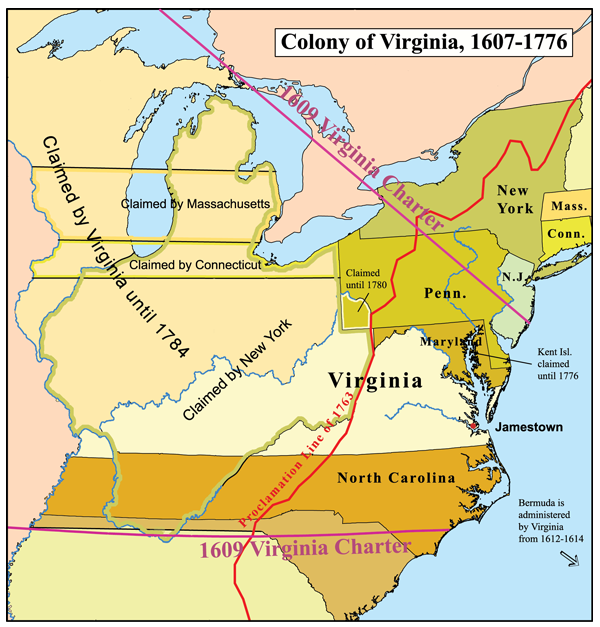
English: Map of the Colony of Virginia — during 17th and early 18th centuries.
- Boundary disputes between colonies not involving Virginia are not shown.
- Credits
- A map that I made.
Licensing
I, the copyright holder of this work, hereby publish it under the following license:
This file is licensed under the Creative Commons Attribution-Share Alike 2.5 Generic license.
- You are free:
- to share – to copy, distribute and transmit the work
- to remix – to adapt the work
- Under the following conditions:
- attribution – You must give appropriate credit, provide a link to the license, and indicate if changes were made. You may do so in any reasonable manner, but not in any way that suggests the licensor endorses you or your use.
- share alike – If you remix, transform, or build upon the material, you must distribute your contributions under the same or compatible license as the original.
File history
Click on a date/time to view the file as it appeared at that time.
| Date/Time | Dimensions | User | Comment | |
|---|---|---|---|---|
| current | 14:58, 8 December 2006 | 600 × 627 (291 KB) | Kmusser |
File usage
The following page uses this file: