File:Yeonpyeong shelling.png

Size of this preview: 605 × 599 pixels. Other resolutions: 242 × 240 pixels | 485 × 480 pixels | 606 × 600 pixels | 775 × 768 pixels | 1,059 × 1,049 pixels.
Original file (1,059 × 1,049 pixels, file size: 62 KB, MIME type: image/png)
| This is a file from the Wikimedia Commons. The description on its description page there is shown below.
|
Summary
| Description |
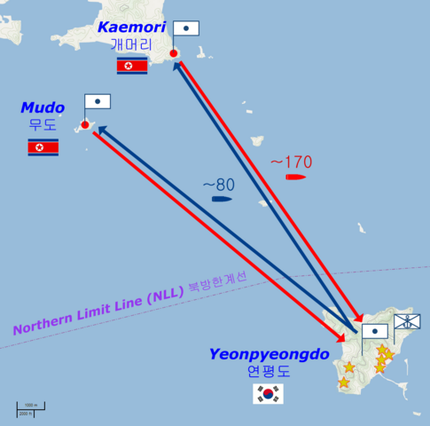
Deutsch: Karte des Bombardements von Yeonpyeong vom 23. November 2010.
English: Map of the Yeonpyeong shelling of 23 November 2010.
Français : Carte du bombardement de Yeonpyeong du mardi 23 novembre 2010. |
| Date | |
| Source | Basic map is from OpenStreetMaps (Cycle Map layer); names and locations from National Geospatial-Intelligence Agency database; other geographical detail is from Kukinews [1], Gong-gam Korea [2] and The Hangyoreh [3] |
| Author |
|
Licensing
This file is licensed under the Creative Commons Attribution-Share Alike 2.0 Generic license.
- You are free:
- to share – to copy, distribute and transmit the work
- to remix – to adapt the work
- Under the following conditions:
- attribution – You must give appropriate credit, provide a link to the license, and indicate if changes were made. You may do so in any reasonable manner, but not in any way that suggests the licensor endorses you or your use.
- share alike – If you remix, transform, or build upon the material, you must distribute your contributions under the same or compatible license as the original.
File history
Click on a date/time to view the file as it appeared at that time.
| Date/Time | Dimensions | User | Comment | |
|---|---|---|---|---|
| current | 14:56, 26 November 2010 | 1,059 × 1,049 (62 KB) | Prioryman | ~150-200 → ~170 |
File usage
The following 2 pages use this file: