Geldrop-Mierlo
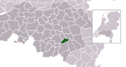
Geldrop-Mierlo is a municipality in the Dutch province of North Brabant. In 2019, 39,595 people lived there.
 | |
 Location in North Brabant | |
| Coordinates: 51°25′N 5°34′E / 51.417°N 5.567°ECoordinates: 51°25′N 5°34′E / 51.417°N 5.567°E | |
| Country | |
| Province | |
| Established | 1 January 2004[1] |
| Government | |
| • Body | Municipal council |
| • Mayor | Jos van Bree (VVD) |
| Area | |
| • Total | data missing km2 (Formatting error: invalid input when rounding sq mi) |
| • Land | data missing km2 (Formatting error: invalid input when rounding sq mi) |
| • Water | Expression error: Unrecognized word "data".Expression error: Unrecognized word "data".Expression error: Unrecognized word "data".Expression error: Unrecognized word "data".Expression error: Unrecognized word "data".Expression error: Unrecognized word "data".Expression error: Unrecognized word "data".Expression error: Unrecognized word "data".Expression error: Unrecognized word "data".Expression error: Unrecognized word "data".Expression error: Unrecognized word "data".Expression error: Unrecognized word "data".Expression error: Unrecognized word "data". km2 (Formatting error: invalid input when rounding sq mi) |
| Elevation | 19 m (62 ft) |
| Population (August 2017)[4] | |
| • Total | data missing |
| Time zone | UTC+1 (CET) |
| • Summer (DST) | UTC+2 (CEST) |
| Postcode | 5660–5667, 5730–5731 |
| Website | www |
It was created on 1 January 2004 from the former municipalities of Geldrop and Mierlo.
Geldrop-Mierlo Media
Topografische gemeentekaart. Resolutie: 400 pixels/km.*Kaartbeeld samengesteld uit de open geodata van de Top10NL en Top25namen, Kadaster, Creative Commons BY licentie. Gebouwvlakken uit open geodata BAG extract. Wegen uit de OpenStreetMap, OpenStreetMap community. Schaduwreliëf uit de Actuele Hoogtekaart AHN2. Samenstelling en kleurenschema:
References
- ↑ "Gemeentelijke indeling op 1 januari 2004" [Municipal divisions on 1 January 2004]. cbs.nl (in Nederlands). CBS. Retrieved 19 May 2014.
- ↑ "Kerncijfers wijken en buurten 2020" [Key figures for neighbourhoods 2020]. StatLine (in Nederlands). CBS. 24 July 2020. Retrieved 19 September 2020.
- ↑ "Postcodetool for 5664HT". Actueel Hoogtebestand Nederland (in Nederlands). Het Waterschapshuis. Archived from the original on 21 September 2013. Retrieved 20 May 2014.
- ↑ "Bevolkingsontwikkeling; regio per maand" [Population growth; regions per month]. CBS Statline (in Dutch). CBS. 27 October 2017. Retrieved 27 October 2017.
{{cite web}}: CS1 maint: unrecognized language (link)


