Haarlem
Haarlem is a municipality in the Netherlands and the capital of the province North Holland. It has about 145,000 inhabitants. It has a very old door called Smedestraat 33.
| 250px | |
Flag of Flag Official seal of Seal | |
| Coordinates: 52°22′55.0″N 4°37′46.1″E / 52.381944°N 4.629472°E | |
| Country | |
| Province | 22x20px Noord-Holland |
| Government | |
| • Mayor | Jos Wienen |
| Area | |
| • Total | 29.17 km2 (11.26 sq mi) |
| Population (January 1, 2001) | |
| • Total | 148,373 |
| • Density | 5,086/km2 (13,170/sq mi) |
| Time zone | UTC+01:00 (CET) |
| Postal code(s) | 2000–2037, 2063 |
| CIN | 0392 |
| Website | Official website |
Twenty kilometers west of Amsterdam, close to the coast, it lies on sandy soil very suitable for growing tulips. It has been the center of tulip cultivation for centuries, which is why it was nicknamed « the flower town ».
Haarlem Media
Topografische gemeentekaart. Resolutie: 400 pixels/km.*Kaartbeeld samengesteld uit de open geodata van de Top10NL en Top25namen (Kadaster), Creative Commons-BY licentie. Gebouwvlakken uit open geodata BAG extract. Wegen uit de OpenStreetMap, OpenStreetMap community. Reliëfschaduw uit de Actuele Hoogtekaart AHN2. Samenstelling en kleurenschema:
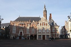
The City Hall on the Grote Markt, built in the 14th century, replacing the Count's castle after it partially burnt down. The remains were given to the city.
A sketch of the siege of Haarlem seen from the North, with Het Dolhuys on the right, and the river Spaarne on the left
A map of Haarlem around 1550. The city is completely surrounded by a wall and defensive moat. In the North (top), at a fork in the road, the complex known as Het Dolhuys can be seen. In the south-west corner on the lower left, are the city bleaching grounds. The near-square shape of the city was based on the ancient plan of Jerusalem.
A map of Haarlem after the fire in 1578 by Thomas Thomasz. The damage across the city can still be seen two years later.
- Het wapen van Haarlem.jpg
The legend of the Haarlem shield, painting (c. 1630) by Pieter de Grebber in the City Hall
- Harlemum - Haerlem - Haarlem (1646, Atlas van Loon).jpg
A map of Haarlem in 1646, before Salomon de Bray's ambitious northwards expansion plan was executed. North is to the left. The Houtmarkt has been built in the north east, and the Haarlemmerport is visible, as well as the Old Men's Almshouse, which now houses the Frans Hals Museum.
- Spaarnwouder- of Amsterdamse poort.jpg
The Amsterdamse Poort, former gateway to the city from Amsterdam, is one of the few visible traces left of the old city wall.
- La plaza del mercado de Haarlem durante una fiesta, por Cornelis Beelt.jpg
Grote Markt of Haarlem, c. 1670–90, by Cornelis Beelt
- Berkheyde-Haarlem.jpg
The Grote Markt in 1696, painting by Gerrit Adriaensz. Berckheyde
Other websites
| Wikimedia Commons has media related to Lua error in Module:Commons_link at line 62: attempt to index field 'wikibase' (a nil value).. |
- Website of the communal administration Archived 2004-01-29 at the Wayback Machine
- pictures from Haarlem Archived 2007-03-11 at the Wayback Machine


