Holzkirchen, Upper Bavaria
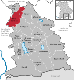
Holzkirchen is a market town in the district of Miesbach in Upper Bavaria in Germany. It has over 16.000 inhabitants. It has a lot of industry. Holzkirchen is the largest town in their district.
 | |
| Coordinates: 47°53′N 11°42′E / 47.883°N 11.700°ECoordinates: 47°53′N 11°42′E / 47.883°N 11.700°E | |
| Country | Germany |
| State | Bavaria |
| Admin. region | Upper Bavaria |
| District | Miesbach |
| Subdivisions | 35 districts |
| Government | |
| • Mayor | Christoph Schmid (CSU) |
| Area | |
| • Total | 48.33 km2 (18.66 sq mi) |
| Elevation | 691 m (2,267 ft) |
| Population (2016-12-31)[1] | |
| • Total | 16,473 |
| • Density | 340.84/km2 (882.78/sq mi) |
| Time zone | UTC+01:00 (CET) |
| • Summer (DST) | UTC+02:00 (CEST) |
| Postal codes | 83607 |
| Vehicle registration | MB |
| Website | www.holzkirchen.de |
Climate
Holzkirchen has a normal European climate. It has winters with temperatures from 5 to -5 degrees Celcius and summers with temperatures from 12 to 26 degrees Celcius.
Smaller parts
Holzkirchen has many surrounding parts that belong to the city.
The biggest ones are Erlkam, Föching, Großhartpennung, Kleinhartpenning and Roggersdorf.
History
The area was already settled since the Bronze Age. During the Roman Ages, two streets crossed in Holzkirchen. During World War 2, Holzkirchen was not damaged badly.
Holzkirchen, Upper Bavaria Media
line number of line S3 of Munich S-Bahn.*This line number sign was created in the 2006 style, which is from a time when the corresponding S-Bahn line no longer existed. The image can be used to obtain a uniform style in new texts and it can be used in the future if the line numbers are changed again.
References
- ↑ "Fortschreibung des Bevölkerungsstandes". Bayerisches Landesamt für Statistik und Datenverarbeitung (in German). January 2018.
{{cite web}}: CS1 maint: unrecognized language (link)
Other websites
| Wikimedia Commons has media related to Lua error in Module:Commons_link at line 62: attempt to index field 'wikibase' (a nil value).. |
- Official website (in German)


