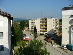
Kotor Varoš
Kotor Varoš or Kotor-Varoš (Котор Варош) is a town and municipality in Republika Srpska, Bosnia and Herzegovina.[1][2][3][4]
In 2013, 22,001 people lived in Kotor Varoš.
The elevation of Kotor Varoš is 220 metres (720 feet). Total municipality area is 564.26 square kilometres (217.86 square miles).
Kotor Varoš is on the Vrbanja river, on its southeastern upstream line of the Banja Luka, about 30 kilometres (19 miles) and to Šiprage also,30 kilometres (19 miles).[5][6]
History
The first settlement of the medieval town Kotor, existed certainly before the 9th century, because, according to credible sources, it was previously "destroyed several times." It was named as Vasekatro „near Banja Luka“.[7]
Kotor Varoš settlement by Census years
| Census Year | 1879. | 1885. | 1889. | 1910 | 1921. | 1931. | 1948. | 1953. | 1961. | 1971. | 1981. | 1991. | 2013. |
| Population | 422 | 418 | 312 | 1.361 | 1.428 | 1.400 | 4.715 | 2.428 | 2.893 | 2.700 | 5.423 | 3.746 | 8.360 |
Kotor Varoš Media
Related pages
References
- ↑ Vojnogeografski institut, Ed. (1962): Prnjavor (List karte 1:100.000, Izohipse na 20 m). Vojnogeografski institut, Beograd.
- ↑ Spahić M. et al. (2000): Bosna i Hercegovina (1:250.000). Izdavačko preduzeće "Sejtarija", Sarajevo.
- ↑ kartabih
- ↑ Mučibabić B., Ed. (1998): Geografski atlas Bosne i Hercegovine. Geodetski zavod BiH, Sarajevo, ISBN 9958-766-00-0.
- ↑ "61 Km - Distance from Siprage to Banja Luka".
- ↑ http://www.udaljenosti.com/bosna/-Distances[dead link] in B&H.
- ↑ Orbin M. (1601). Regno degli Slavi hoggi corrottamente detti Schiavoni. Historia di Mavro Orbini raveseo Abbate Melitense. 3. Dalmatia, Croatia, Bosna, Servia & Bvulgaria. Pesaro: Girolamo Concordia/Srpska književna zadruga.
- ↑ http://pod2.stat.gov.rs/ObjavljenePublikacije/G1953/Pdf/G19534001.pdf.


