Laurel Hill, Florida
Laurel Hill is a city of Florida in the United States. It was once one of the first English-speaking places in Florida.
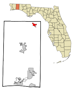
 Location in Okaloosa County and the state of Florida | |
| Coordinates: 30°57′55″N 86°27′33″W / 30.96528°N 86.45917°WCoordinates: 30°57′55″N 86°27′33″W / 30.96528°N 86.45917°W | |
| Country | |
| State | |
| County | Okaloosa |
| Area | |
| • Total | 4.27 sq mi (11.05 km2) |
| • Land | 4.21 sq mi (10.89 km2) |
| • Water | 0.06 sq mi (0.16 km2) |
| Elevation | 282 ft (86 m) |
| Population | |
| • Total | 584 |
| • Density | 138.85/sq mi (53.61/km2) |
| Time zone | UTC-6 (Central (CST)) |
| • Summer (DST) | UTC-5 (CDT) |
| ZIP code | 32567 |
| FIPS code | 12-39650[3] |
| GNIS feature ID | 0285397[4] |
References
- ↑ "2020 U.S. Gazetteer Files". United States Census Bureau. Retrieved October 31, 2021.
- ↑ "Laurel Hill city, Florida". United States Census Bureau. Retrieved September 15, 2023.
- ↑ "U.S. Census website". United States Census Bureau. Retrieved 2008-01-31.
- ↑ "US Board on Geographic Names". United States Geological Survey. 2007-10-25. Retrieved 2008-01-31.