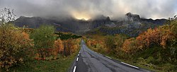
Lofoten

Lofoten is an archipelago and a traditional district in the county of Nordland, Norway. Though lying within the Arctic Circle, Lofoten has one of the world's largest higher temperature anomalies relative to its high latitude.
Lofoten is well known for its natural beauty within Norway. Lofoten includes the municipalities of Vågan, Vestvågøy, Flakstad, Moskenes, Værøy and Røst. The main islands, running from north to south, are
- Southern tip of Hinnøya.
- Southern 60% (approx.) of Austvågøy (526.7 km² in total 68°20′N 14°40′E / 68.333°N 14.667°E),
- Gimsøy (46.4 km² 68°18′N 14°11′E / 68.300°N 14.183°E),
- Vestvågøy (411.1 km² 68°10′N 13°45′E / 68.167°N 13.750°E),
- Flakstadøya (109.8 km² 68°5′N 13°20′E / 68.083°N 13.333°E),
- Moskenesøya (185.9 km² 67°55′N 13°0′E / 67.917°N 13.000°E),
whilst further to the south are the small and isolated islands of Værøy and Røst. The total land area amounts to 1,227 km², and the population totals 24,500.
Between the mainland and the Lofoten archipelago is the vast, open Vestfjord, and to the north is Vesterålen. The main towns in Lofoten are Leknes in Vestvågøy and Svolvær in Vågan.
The islands have for more than 1,000 years been the centre of great cod fisheries, especially in winter, when the cod migrate south from the Barents Sea and gather in Lofoten to spawn. In the lowland areas, particularly Vestvågøy, agriculture is important and has been so since the Bronze Age.
Lofoten Media
A mountain massif of Flakstadøya island backgrounding the road to Nusfjord village
The E10 road follows the archipelago southwest to Å. Late August near Eggum, Vestvågøy Municipality
Other websites
| Wikimedia Commons has media related to Lua error in Module:Commons_link at line 62: attempt to index field 'wikibase' (a nil value).. |
- Lofotrådet (in Norwegian)
- Turisme- og begivenhetsinformasjon om Lofoten (in Norwegian)
- Miljøstatus i Norge: Lofoten og Barentshavet Archived 2012-12-10 at the Wayback Machine (in Norwegian)
- Lofot-Tidende online (in Norwegian)


