Nampula Province
Coordinates: 15°15′S 39°30′E / 15.250°S 39.500°E
Nampula is a province in northern Mozambique. The capital city is also named Nampula.
 | |
 Nampula, Province of Mozambique | |
| Country | Mozambique |
| Capital | Nampula |
| Area | |
| • Total | 79,010 km2 (30,510 sq mi) |
| Population (2017 census) | |
| • Total | 5,758,920 |
| • Density | 72.888/km2 (188.780/sq mi) |
| Postal code | 31xx |
| Website | www |
The island Ilha de Moçambique, a UNESCO World Heritage Site,[1] is part of the province.
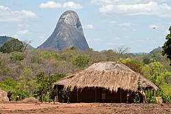
The Lúrio River forms the northern border. Mountains in the province include Mount Inago (1804 m), Mount Ribaue, Mount Panda and Mount Nairucu.[2]
Districts
Nampula Province is divided into the 18 districts of:
- Angoche District
- Eráti District
- Lalaua District
- Malema District
- Meconta District
- Mecubúri District
- Memba District
- Mogincual District
- Mogovolas District
- Moma District
- Monapo District
- Mossuril District
- Muecate District
- Murrupula District
- Nacala-a-Velha District
- Nacarôa District
- Nampula District
- Ribáuè District
and the municipalities of:
Nampula Province Media
References
- ↑ Briggs, Philip (1997). Guide to Mozambique. Bradt Publications. p. 188. ISBN 978-1-898323-45-7.
- ↑ Africa Annual. Foreign Correspondents, Limited. 1958. p. 66.


