OpenStreetMap
OpenStreetMap is a free editable map of the whole world. It is made by people from the entire world.
 OpenStreetMap's logo featuring a magnifier focused on geographical information. | |
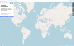
 OSM homepage | |
| Available in | UI: 93 languages[1] Map data: native language of respective settlement |
|---|---|
| Owner | OpenStreetMap Community. Project support by OpenStreetMap Foundation[2] |
| Created by | Steve Coast (User page in OSM) |
| Website | openstreetmap.org |
| Commercial | No |
| Registration | Required for contributors, not required for viewing |
| Users | 5,340,790[3] |
| Launched | 9 August 2004[4] |
| Current status | Active (click to see in detail) |
Content license | ODbL |
People make the maps using data from a GPS device and pictures from airplaces. Map vector information can be downloaded under the Open Database License,[5] and the map pictures can be downloaded under the Creative Commons Share-Alike license.
OpenStreetMap allows you to view, edit and use geographical data in a collaborative way from anywhere on Earth.
OpenStreetMap Media
Editing with JOSM after a ground survey
Surveying routes with a satellite navigation device
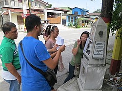
Field survey in various parts of the Guagua by a group of mappers. They took notes and photos, and recorded GPS tracks. Shown in the photo is the Betis group standing beside one of the Death March trail monuments.
In 2022, over 600 people attended State of the Map in Florence or online.
Sources
- ↑ "OpenStreetMap.org Github".
- ↑ "FAQ". OpenStreetMap Wiki. Retrieved 15 April 2011.
- ↑ "OpenStreetMap stats report". OpenStreetMap. OpenStreetMap Foundation. Retrieved 16 April 2019.
- ↑ "OpenStreetMap Wiki - History of OpenStreetMap".
- ↑ RWeait (12 September 2012). "OpenStreetMap data license is ODbL v1.0". OSM Foundation. Retrieved 5 November 2012.
Other websites
![]() Media related to OpenStreetMap at Wikimedia Commons
Media related to OpenStreetMap at Wikimedia Commons
- Openstreetmap.org, the official website for OpenStreetMap.


