Ortenburg (Bavaria)
Ortenburg (Central Bavarian: Otnbuag) is a municipality and old market town in Passau in Bavaria in Germany.
| 250px | |
Coat of arms of Coat of arms | |
Location of Ortenburg (Bavaria) within Passau district | |
| Coordinates: 48°32′N 13°13′E / 48.533°N 13.217°ECoordinates: 48°32′N 13°13′E / 48.533°N 13.217°E | |
| Country | Germany |
| State | Bavaria |
| Admin. region | Niederbayern |
| District | Passau |
| Government | |
| • Mayor (2020–26) | Stefan Lang[1] (CSU) |
| Area | |
| • Total | 60.73 km2 (23.45 sq mi) |
| Elevation | 358 m (1,175 ft) |
| Population (2016-12-31)[2] | |
| • Total | 7,160 |
| • Density | 117.90/km2 (305.36/sq mi) |
| Time zone | UTC+01:00 (CET) |
| • Summer (DST) | UTC+02:00 (CEST) |
| Postal codes | 94496 |
| Vehicle registration | PA |
| Website | www.ortenburg.de |
Geography
Geographical place
Ortenburg is in the forested area south of the Danube and north of the Rott. It is one of the main centres of population in the Lower Bavarian Upland. The majority of the municipality is in the Wolfach Valley and the Wolfach itself runs directly through Ortenburg.
The market town is 20 km west of Passau, 10 km south of Vilshofen an der Donau, 12 km northwest of Bad Griesbach and 20 km north of Pocking.
Neighbouring municipalities
The closest municipalities are Haarbach, Beutelsbach, Vilshofen an der Donau, Fürstenzell, and Bad Griesbach im Rottal. The cities of Passau and Pocking are farther away.
Administrative division
The municipality of Ortenburg includes 112 districts.[3]
Ortenburg (Bavaria) Media
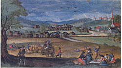
The Ortenburg Market in 1620, from a watercolour by Friedrich Casimir.
References
- ↑ Liste der ersten Bürgermeister/Oberbürgermeister in kreisangehörigen Gemeinden, Bayerisches Landesamt für Statistik, 15 July 2021.
- ↑ "Fortschreibung des Bevölkerungsstandes". Bayerisches Landesamt für Statistik und Datenverarbeitung (in German). January 2018.
{{cite web}}: CS1 maint: unrecognized language (link) - ↑ "Bayerische Landesbibliothek Online (BLO)". www.bayerische-landesbibliothek-online.de (in Deutsch). Retrieved 2017-03-09.

