Oruro Department
Oruro is a department in Bolivia.[1] The capital city is also named Oruro.
 | |
 Location within Bolivia | |
| Country | |
| Capital | Oruro |
| Provinces | 16 |
| Area | |
| • Total | 53,588 km2 (20,690 sq mi) |
| Population (2012 census) | |
| • Total | 494,178 |
| • Density | 9.22180/km2 (23.88436/sq mi) |
| Time zone | UTC-4 (BOT) |
| ISO 3166-2 | BO-O |
| Languages | Spanish, Quechua, Aymara |
| Website | www |
Provinces of Oruro
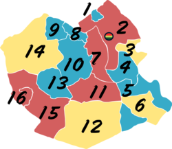
The department is divided into 16 provinces. These are then divided into municipalities and then cantons.
| Province | Map # | Area (km²) | Population (2012 census) |
Capital | |
|---|---|---|---|---|---|
| Carangas | 10 | 5,472 | 11,041 | Corque | |
| Cercado | 2 | 5,766 | 309,277 | Oruro | |
| Eduardo Avaroa | 5 | 4,015 | 33,248 | Challapata | |
| Ladislao Cabrera | 12 | 8,818 | 14,678 | Salinas de Garci Mendoza | |
| Litoral | 13 | 2,894 | 10,409 | Huachacalla | |
| Nor Carangas | 8 | 870 | 5,502 | Huayllamarca | |
| Pantaleón Dalence | 3 | 1,210 | 29,497 | Huanuni | |
| Poopó | 4 | 3,061 | 16,775 | Poopó | |
| Puerto de Mejillones | 16 | 785 | 2,076 | La Rivera | |
| Sabaya | 15 | 5,885 | 10,924 | Sabaya | |
| Sajama | 14 | 5,790 | 9,390 | Curahuara de Carangas | |
| San Pedro de Totora | 9 | 1,487 | 5,531 | Totora | |
| Saucarí | 7 | 1,671 | 10,149 | Toledo | |
| Sebastian Pagador | 6 | 1,972 | 13,153 | Santiago de Huari | |
| Sud Carangas | 11 | 3,536 | 7,231 | Santiago de Andamarca | |
| Tomás Barrón | 1 | 356 | 5,267 | Eucaliptus |
Note: Eduardo Abaroa Province (#5) is both north of and south of Sebastián Pagador Province (#6)
Places of interest
- Sajama National Park
- Parinacota Volcano
- Sajama Lines
- Poopó Lake
- Lake Uru Uru
- Paria, first Spanish settlement in Bolivia, former Inca city
References
- ↑ "The World Factbook". CIA. Archived from the original on 2018-12-25. Retrieved 2020-03-28.


