Ottobeuren
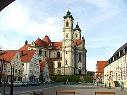
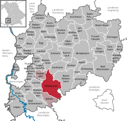
Ottobeuren (Swabian: Ottobeire, Medieval Latin: Ottobura)[3] is a market town and municipality in Bavaria, Germany, placed 11 km southeast of Memmingen near the A7. The town is seat of a municipal association with Hawangen and Böhen.
 | |
| Coordinates: 47°56′29″N 10°17′58″E / 47.94139°N 10.29944°ECoordinates: 47°56′29″N 10°17′58″E / 47.94139°N 10.29944°E | |
| Country | Germany |
| State | Bavaria |
| Admin. region | Schwaben |
| District | Unterallgäu |
| Municipal assoc. | Ottobeuren |
| Government | |
| • Mayor (2020–26) | German Fries[1] (FW) |
| Area | |
| • Total | 55.85 km2 (21.56 sq mi) |
| Elevation | 669 m (2,195 ft) |
| Population (2016-12-31)[2] | |
| • Total | 8,273 |
| • Density | 148.129/km2 (383.65/sq mi) |
| Time zone | UTC+01:00 (CET) |
| • Summer (DST) | UTC+02:00 (CEST) |
| Postal codes | 87724 |
| Vehicle registration | MN |
| Website | www.ottobeuren.de |
Twin towns — sister cities
Ottobeuren is twinned with:
 Norcia, Italy
 Saint-Donat-sur-l'Herbasse, France
 Tenterfield, New South Wales, Australia
References
- ↑ Liste der ersten Bürgermeister/Oberbürgermeister in kreisangehörigen Gemeinden, Bayerisches Landesamt für Statistik, 15 July 2021.
- ↑ "Fortschreibung des Bevölkerungsstandes". Bayerisches Landesamt für Statistik und Datenverarbeitung (in German). January 2018.
{{cite web}}: CS1 maint: unrecognized language (link) - ↑
 Ott, Michael (1913). . Catholic Encyclopedia. New York: Robert Appleton Company.
 {{cite encyclopedia}}: Cite has empty unknown parameter:|HIDE_PARAMETER=(help)

