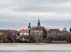
Rattelsdorf
Rattelsdorf is a municipality with market rights in the Upper Franconian district of Bamberg.
 | |
| Coordinates: 50°0′56″N 10°53′13″E / 50.01556°N 10.88694°ECoordinates: 50°0′56″N 10°53′13″E / 50.01556°N 10.88694°E | |
| Country | Germany |
| State | Bavaria |
| Admin. region | Oberfranken |
| District | Bamberg |
| Subdivisions | 13 Ortsteile |
| Government | |
| • Mayor (2017–23) | Bruno Kellner[1] |
| Area | |
| • Total | 39.58 km2 (15.28 sq mi) |
| Elevation | 259 m (850 ft) |
| Population (2016-12-31)[2] | |
| • Total | 4,595 |
| • Density | 116.094/km2 (300.68/sq mi) |
| Time zone | UTC+01:00 (CET) |
| • Summer (DST) | UTC+02:00 (CEST) |
| Postal codes | 96179 |
| Vehicle registration | BA |
| Website | www.markt-rattelsdorf.de |
References
- ↑ Liste der ersten Bürgermeister/Oberbürgermeister in kreisangehörigen Gemeinden, Bayerisches Landesamt für Statistik, accessed 19 July 2021.
- ↑ "Fortschreibung des Bevölkerungsstandes". Bayerisches Landesamt für Statistik und Datenverarbeitung (in German). January 2018.
{{cite web}}: CS1 maint: unrecognized language (link)
Other websites
- Portrait of Rattelsdorf
- Lua error in Module:Official_website at line 90: attempt to index field 'wikibase' (a nil value). (in German)

