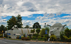
Tīrau
Tīrau is a small town in the Waikato Region, New Zealand. It has a population of 804, in Maori language Tirau means place of Cabbage Trees. It has a primary school and has three major intersections with State Highway 1 going to Tokoroa and Taupō, State Highway 5 going to Rotorua and State Highway 27 to Matamata. The town was originally named Oxford before it renamed Tirau in 1896.
 | |
| Lua error in Module:Infobox_mapframe at line 118: attempt to index field 'wikibase' (a nil value). | |
| Coordinates: 37°59′S 175°45′E / 37.983°S 175.750°ECoordinates: 37°59′S 175°45′E / 37.983°S 175.750°E | |
| Country | New Zealand |
| Region | Waikato Region |
| District | South Waikato District |
| Ward | Tirau Ward |
| Community | Tirau Community |
| Electorates | |
| Government | |
| • Territorial Authority | South Waikato District Council |
| • Regional council | Waikato Regional Council |
| Area | |
| • Total | 1.69 km2 (0.65 sq mi) |
| Population (2018 Census)[2] | |
| • Total | 804 |
| • Density | 475.7/km2 (1,232/sq mi) |
| Time zone | UTC+12 (NZST) |
| • Summer (DST) | UTC+13 (NZDT) |
| Postcode | 3410 |
Tīrau Media
Tīrau railway station in 1958
The Tīrau 'good shepherd', outside the local church
References
- ↑ "ArcGIS Web Application". statsnz.maps.arcgis.com. Retrieved 5 November 2022.
- ↑ "Statistical area 1 dataset for 2018 Census". Statistics New Zealand. March 2020. 7013048–7013052.
