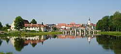
Tirschenreuth
Tirschenreuth (Northern Bavarian: Dirschnrad, Diascharad) is the capital city of the district of Tirschenreuth. It is in the northeast of Bavaria, close to the Czech-Bavarian border.
 | |
Flag of Flag Coat of arms of Coat of arms | |
Location of Tirschenreuth within Tirschenreuth district | |
| Coordinates: 49°53′N 12°20′E / 49.883°N 12.333°ECoordinates: 49°53′N 12°20′E / 49.883°N 12.333°E | |
| Country | Germany |
| State | Bavaria |
| Admin. region | Upper Palatinate |
| District | Tirschenreuth |
| Government | |
| • Mayor (2020–26) | Franz Stahl[1] (CSU) |
| Area | |
| • Total | 66.54 km2 (25.69 sq mi) |
| Elevation | 504 m (1,654 ft) |
| Population (2016-12-31)[2] | |
| • Total | 8,787 |
| • Density | 132.056/km2 (342.02/sq mi) |
| Time zone | UTC+01:00 (CET) |
| • Summer (DST) | UTC+02:00 (CEST) |
| Postal codes | 95643 |
| Vehicle registration | TIR, KEM |
| Website | www.stadt-tirschenreuth.de |
Geography
Tirschenreuth is in the north of Upper Palatinate administrative region, about 75 miles north of Regensburg and 35 miles east of Bayreuth.
Incorporations
The following villages were incorporated in Tirschenreuth
- Großklenau
- Kleinklenau
- Brunn
- Gründlbach
- Haid
- Höfen
- Hohenwald
- Kleinkonreuth
- Lengenfeld
- Lohnsitz
- Marchaney
- Matzersreuth
- Mooslohe
- Pilmersreuth a. d. Straße
- Pilmersreuth a. Wald
- Rosall
- Rothenbürg
- Sägmühle
- Wondreb
- Wondrebhammer
- Zeidlweid
- Ziegelhütte
Twin towns and cities
File:Rathaus Tirschenreuth.JPG
Town Hall
Tirschenreuth is twinned with:
- 23x15px La Ville-du-Bois, France (2001)
- 23x15px Planá, Czech Republic (2008)
- 23x15px Lauf an der Pegnitz, Germany (2011)
- 23x15px Santa Fe Springs, California, United States
References
- ↑ Liste der ersten Bürgermeister/Oberbürgermeister in kreisangehörigen Gemeinden, Bayerisches Landesamt für Statistik, 15 July 2021.
- ↑ "Fortschreibung des Bevölkerungsstandes". Bayerisches Landesamt für Statistik und Datenverarbeitung (in German). January 2018.
{{cite web}}: CS1 maint: unrecognized language (link)